Showing posts with label road trips. Show all posts

Saturday, December 28, 2019

The countdown has begun

We moved the new mini-fridge into the Guppy yesterday, and the S.O. completed what he hopes is the last mechanical repair. If all goes as currently planned, two weeks from now we'll be somewhere considerably farther south and west.

The Original Plan had been to hit the road right after Thanksgiving, but a dental appointment I cannot miss got pushed back to January 3, which kind of meant we're here until then. I wasn't happy about the appointment not happening until after the holidays, but there was nothing I could do about it.

The change in plans does mean slightly less ambling -- we had planned to start off going southeast into Kentucky and Alabama before swinging west. Now we're going to just aim for Texas and the southwest. Not sure just what all we'll do in Texas, but I do want to cross Guadalupe Mountains National Park off the list of parks I haven't been to yet. For sure we'll stop in New Mexico at White Sands National Park (newest one to get the NP designation in the system; it was upgraded from a National Monument about a week ago). I want to go to Lincoln, New Mexico, too, and visit the grave of Smokey Bear, but the S.O. may feel that's a side trip that's just a little too weird for him.

The final mechanical repair was to replace the calipers for the brakes on one front wheel. The S.O. noticed the brake shoes were hanging up as we were coming back from Pictured Rocks on September 30. He'd tried a couple things to see if that would make a difference, but finally bit the bullet, bought new calipers, and replaced them yesterday. We need to get stuff secured in the house part of the Guppy before he can do a test run to make sure the fix worked, but we need to secure stuff in any case.

The Plan for today is for him to get the doors back on the mini-fridge and for me to do Other Stuff, like securing various things that might bounce in ways we don't want them to bounce if they're not secured. I will start moving some clothes into the bedroom closet and drawers, too. I certainly will not be wearing my high water pants or sandals around here in the next two weeks. We may try to get some Reflectix cut to fit the windshield and other windows in the cab, too, while we're thinking about it.

We already did Reflectix on two windows in the bedroom. It turns the space into a cave, but it'll come off easy when we get to a place where it's warm enough that we don't have to worry as much about either keeping things warm or preventing condensation.

As for the mini-fridge, it's electric only so obviously we can only use it when we're parked were there's electricity. If we boondock it's basically just a pantry. It's a just-in-case fridge. My niece and her family spent a few weeks living in the Guppy when they relocated to the U.P.  in May. The original equipment refrigerator, which is now 30 years old, was in continuous operation for about a month and decided it didn't like it. First, it apparently began tripping a breaker when it was running on electricity. So we switched it over to propane. It worked okay for awhile, and then it did the same thing: decided it was time to quit. Given the age of the appliance, we figured it had reached the end of its useful life. We bought a mini-fridge and set it up in the Woman Cave so Bonnie would have a place to keep milk and other perishables instead of having to mess with a cooler.

We had experienced problems with the refrigerator while we were at Pictured Rocks in 2018. We were running it on propane and after about two weeks it quit. We got ice and used it like a cooler. It deciding to quit again this summer was not a huge surprise. We had been debating getting a small refrigerator, something bigger than a dorm fridge but not a real residential model. You know, something like the refrigerators you find in hotel rooms. The S.O. measured the space where the built-in refrigerator is and we looked for a small refrigerator that could go into that same space if that's what we wanted to do. We did not seriously consider purchasing an actual dual-power (gas or alternating current) RV refrigerator. We only paid $3,000 for the Guppy. We're not putting anything into it where the price includes a comma. We're old. Realistically, we don't have too many more years left of doing things like campground hosting or long road trips. [How much does one of those dual power refrigerators cost, you ask? The Old Fat Man described replacing one in his travel trailer recently. It ran about $1,800.]

The built-in fridge actually worked better at Pictured Rocks this year. It ran fine on propane most of the time. Every so often we'd notice that the temperature in it seemed to be climbing when it shouldn't so we'd turn it off. We'd let it rest for awhile, and then turn it back on and it would work again. Odd, and definitely a clue it's going to quit for good soon.

In any case, the new refrigerator is big enough that it has a separate freezer compartment. We know from it being used this summer that the freezer really works and it is big enough to hold frozen pizzas and the 1.5 quart size cartons of ice cream. Its overall capacity is less than what the original equipment fridge would hold, but it's more than big enough for just the two of us. I've never understood the point of having humongous refrigerators that hold enough provisions for a small army. All that happens is things migrate to the back of shelves and turn into science experiments and mold farms.

For now the new fridge is in a corner in the "living room" where we had a storage box. It fits into the space nicely, actually has a slightly smaller footprint than the box did, so it's not eating up much square footage. It's going to start out functioning more as a pantry; the old fridge is currently stocked with frozen water bottles so that's going to be where I stick whatever perishable food we have when we hit the road. Next summer we'll deal with the issue of what to do with the old refrigerator: leave it in place and turn into a full-time definitely mouse-proof pantry, pull it and put the new fridge into that space, or pull it and turn the space into storage.

I know there are people who will wonder how I can talk so openly about us disappearing over the horizon for a few months. "Isn't that an open invitation to burglars?" Well, no. Not if it snows -- and it will. Thieves are lazy. They're not going to bother a place that's at the end of a 600 foot unplowed driveway. And even if they do? Doomed to disappointment. I don't think we own a thing that would be worth stealing.

Saturday, February 17, 2018

El Morro National Monument

And yet another extremely belated post in the ongoing series "How I Spent My Winter Vacation."

El Morro is an interesting little park in northern New Mexico. It's located on what used to be the main route between Albuquerque and points west because it has year-round water. The water is a natural pond formed by run-off from a bluff. No doubt in times of extreme drought the water could dry up, but in general the sheltered location -- not much direct sunlight and protected from the wind -- would slow evaporation. There was an ancient Puebloan village on the top of the bluff, and the site quickly became known to the Spanish explorers.

The rock bluff itself with its vertical walls and soft sandstone had become a favorite spot for graffiti long before European explorers arrived in the Southwest. Native peoples carved petroglyphs into the rock, some of which may have had symbolic meanings and some of which were no doubt the equivalent of "Kilroy was here." I tend to believe that a lot of what archaeologists attempt to read deep meanings into when they're studying ancient rock art today is actually the equivalent of doodling, people sitting around killing time before the evening meal or heading out to go hunting, and had no more significance at the time of its creation than the doodles I used to create while trying to stay awake in staff meetings.

I also tend to believe that's why so much of the ancient rock art that is found includes lot of "fertility symbols.*" Just think about high school for a minute or two and recall what the perpetually love-starved adolescent males used to doodle in notebooks when they should have been doing algebra problems. A biological imperative is a biological imperative. Lust is lust. And sometimes a fertility symbol is one person's fixation on getting laid and not an entire culture's expression of goddess worship. But I digress.

We stopped at El Morro in late February on our way back to Safford from Grand Junction. We decided to take a different route south than we had north so had aimed for Gallup, New Mexico. We spent the night there and then I suggested we check out El Morro as part of heading down to connect with US-180. It was a cold morning and had snowed during the night. When we checked in at the Visitor Center, the ranger warned us that the trail was pretty slick. We took our time in the Visitor Center to give the sun a little more time to work on melting the ice and snow and then walked the trail loop backwards to avoid having to go down a fairly steep hill. The trail loop is paved so once the sun hit it the snow and ice melted fast. Still, given a choice between sliding down an ice-covered sidewalk and crawling up one, I always figure the crawling up is safer. The only drawback was, of course, that we saw the interpretive signage in reverse order. Was that an issue? Not really. 

There are actually two trails from the Visitor Center. One goes down to the water and then along the base of the bluff past the gazillion rock carvings; the other goes up to the ruins of the pueblo on the top of the bluff. The snow and ice on the trails convinced us the smart move would be to save the pueblo trail for another time.

The carvings themselves are interesting. Some have become weathered almost to the point of being unreadable; others still look really sharp. A few experienced damage from well-intentioned but misguided attempts at preservation. The carvings go back hundreds of years with many predating the arrival of the Spanish in New Mexico. Once the Spanish did arrive, being typical arrogant asshats the first carving they did was superimposed on ancient carvings. Visitors to the site kept right on carving on the rock until the site was declared a National Historic Monument and what had been a normal cultural practice for centuries turned into vandalism. I'm not sure exactly how recent the last "historic" carving is. The first Spanish one makes an impression; the last American tourist is a bit more obscure.

ELMO is located west of El Malpais National Monument, a park created to preserve and highlight its interesting geological features. We did not drive the few miles east to see ELMA, too, but may check it out the next time we're in New Mexico. It's not that far from the Interstate so would be an easy side trip.

In addition to the Visitor Center and interpretive trails, ELMO includes a small rustic campground. We did a drive through, and to me the sites looked small. It struck me as being a good place for tent camping or with a small RV or travel trailer. It's definitely not designed with Class As or humongous 5th wheel trailers in mind.

The pool is tucked in behind the fence where the people are standing. 

*Usually representations of female genitalia because they're easy to draw. 

Sunday, March 5, 2017

Petrified Forest National Park

Colorful rocks are petrified wood and they're a lot bigger than the photo suggests.
Last installment of the Grand Canyon road trip. Honest.
View of the Painted Desert

I have been known to toss out the occasional disparaging comment about "windshield tourists." Well, Petrified Forest National Park is a park designed with windshield tourists in mind. The park is meant to be toured by car: its scenic drive wends it way from north to south (or south to north, depending on which end you enter the park from) stopping at a number of overlooks and points of interest along the way. You start with views of the Painted Desert and end by crusing through the Petrified Forest, complete with giant logs, or vice versa.
Painted Desert Inn

We entered the park at the north end, from the exit on I-40, stopped at the Visitor Center there, and then ambled southward. At both the Visitor Center and at the Painted Desert Inn volunteers gave me a pep talk about being a VIP at the park. We noticed the park's VIP RV site close to the Visitor Center; it appeared to be more than adequate in terms of creature comforts for anyone volunteering there. You know, full hookups, decent parking pads, etc., and possibly even some natural shade in the form of trees.

Both volunteers I spoke with mentioned the park has a real need for help during the summer. No surprise there -- no one in their right mind picks Arizona as a place to be a VIP in July and August, with the possible exceptions of being tucked away in the mountains somewhere, like maybe campground hosting up in the pines at about the 7,000 foot level. To be honest, though, I'm not sure I'd want to be at Petrified Forest NP other than passing through at any time of the year. The landscape is a just a little too unearthly for me.

Anyway, north of the Interstate, the viewscape tends to be the Painted Desert. Very colorful and also very alien. At some of the overlooks, you look out at a landscape that appears to be pretty much devoid of life of any sort. No vegetation, nothing.

It is possible to go hiking and back country camping at Petrified Forest. In fact, a hiking trail down into the Painted Desert Wilderness starts near the Painted Desert Inn. The big question I have is "Why?" I can understand (maybe) the desire to do a hike that would take a person away from the tour road and out of hearing range of the Interstate (although it is astounding just how far traffic noises can carry when there's not much wind and no other competing ambient sounds) but why would you want to camp out there? It is, after all, an environment in which guessing wrong on just how much water to carry can get you killed. But maybe that's part of the attraction: the easiest sort of X-game to play, one where all you have to do to risk your life is underestimate how much water you're going to need to survive the trek back to your car.

Back, to get back to the tour, when you begin at the I-40 end, you start off by getting to stare at the Painted Desert and pause at the Painted Desert Inn, a popular tourist stop operated by the Fred Harvey company back in the heyday of Route 66. At some point the Inn faded into run-down shabbiness and closed in the mid-1960s; the Park Service came close to demolishing it in the 1970s. No doubt the completion of Interstate 40 and the overall increase in the speed of travel contributed to its demise. A lot of stuff by the side of the road vanished when people no longer had to slow down for every local intersection. In the case of the Painted Desert Inn, a campaign to preserve it eventually resulted in it being listed as a National Historic Landmark. It has been thoroughly restored and now serves as a point of interest in the park.

Like a number of the western parks, Petrified Forest had a local artisan working on (and selling) traditional craft items, jewelry in this case, at the Inn. I fear I'm enough of a cynic that I find myself thinking of those people as the token Indians. Hey, we stole your country from your people, but here's a spot to set up your table to sell trinkets to the tourists and we'll maybe acknowledge that Kit Carson was a genocidal asshole and include a panel or two on a wayside that mentions the Long Walk. Maybe.

Then again I don't have the type of personality that would find it rewarding to work on anything with an audience staring at me so have a hard time imagining that someone else might actually like being in that position. And for sure if you're making jewelry to sell it is kind of nice to have the customers come to you instead of having to hassle with placing it in stores or going to craft fairs.

Moving on from the Painted Desert Inn, there are a couple more overlooks to enable more staring at alien landscapes before you hit the Route 66 exhibit on the north side of I-40. This being Arizona, I tend to think the addition of a dessicated skeleton and a vulture or two ("it's a dry heat") would improve the wayside, but I doubt the people who design interpretive displays would agree.

South of I-40, you hit a couple points of interest and overlooks that highlight Native American history and Puebloan culture. There's the usual pueblo ruin -- I must confess I'm getting to the point where I tend to think after you've seen one set of crumbling rock walls you've seen them all; the only big difference is in the color of the local stone -- as well as some interesting petroglyphs. One site has a spiral petroglyph that is hit directly by the sun on only one day of the year (the summer solstice), as well as a lot of petroglyphs of what archeologists assure us are images of mountain lions but to me always look suspiciously like lizards, maybe because of the exaggerated claws. Petroglyphs are drawings carved into the rock, usually on surfaces that were covered with "desert varnish" so there's a contrast between the dark surface and the underlying lighter colored stone.

One of the overlooks is at a site called Newspaper Rock. Supposedly there are a gazillion petroglyphs carved into the stone below the overlook. I don't know if it was the angle of the lighting when we were there or if a lot of them have just eroded or faded through time, but there didn't seem to be enough of them to merit having a special name and dedicated overlook. Then again, maybe the engineers who laid out the road calculated they needed overlooks or stops of some sort at certain intervals to keep traffic appropriately slow for a scenic byway and the petroglyphs happened to be the most interesting thing available at that particular point. I wasn't the only person underwhelmed by Newspaper Rock. A fellow who was traveling north stopped at the pueblo ruin and said the petroglyphs there were more numerous and easier to see than the ones a couple miles down the road.

After Newspaper Rock, the road gets into badlands and the actual petrified forest. Once again, it's a thoroughly other worldly landscape, very arid and empty but with these humongous chunks of what used to be trees, really big trees, millions of years ago. The trees were buried by mud, the mud hardened into sandstone, various minerals migrated into the trees (I have no idea how that process would work, but it obviously did). The petrified trees wound up being harder than the surrounding soft sandstone so as the sandstone erodes, the trees are exposed. In a few cases, some remarkably long intact pieces remain, but in general as the sandstone eroded and the trees dropped they fractured into pieces that look so neatly done that you'd swear they were cut on purpose. Nope, just a trick of nature and the natural fracture lines in the crystals.
Note large petrified log perched on top of eroding hill.
There are a couple examples of long logs that were in danger of dropping and breaking in past decades that the Park Service stabilized. Current literature notes that if a similar situation were to develop today the policy would be to just let it happen, allow natural forces to proceed unimpeded, and simply update the interpretive material. On one level, a person can applaud that decision. Yes, it is always better not to mess with Mother Nature, even if it just a case of preventing a stone log from rolling and breaking. On the other hand, and once again the cynic emerges, as the long as the object in question isn't a potential safety hazard, it's a whole lot cheaper to do nothing and then revise a trail brochure than it is to get a maintenance crew together, purchase materials, and build something to stabilize an eroding chunk of rock.

There is a Visitor Center at the south end of the park, too. It has a small museum area that emphasizes dinosaurs and fossil finds. A short trail behind the Visitor Center leads you through an assortment of giant petrified logs or log fragments. It was suprisingly interesting. You'd think that after you've seen a couple giant chunks of petrified wood you'd have seen them all, but nope, not quite true.
Humongous petrified log with concrete pad inserted under it to prevent its collapse.
We didn't spend quite as much time at Petrified Forest as a person could even if they are just doing the windshield route. It was colder, windier, and rainier than we would have preferred so we skipped or cut short a couple short trail hikes. It didn't help that the rain included hail. 

Wednesday, February 15, 2017

Walnut Canyon National Monument

Installment Whatever of the Travelogue: Walnut Canyon National Monument.

After spending the night in Flagstaff, the trek continued. Checked out of the motel, got on to I-40, and then three miles down the road got off I-40. Walnut Canyon has to be one of the easiest parks in the National Parks system to visit: conveniently close to Flagstaff and with a dedicated freeway exit.
Walnut Canyon was popular with tourists long before it was designated as a national monument. Its numerous cliff dwellings began attracting visitors in the 19th century. Many of the ancient cave dwellings were vandalized and graves desecrated as pot hunters and tourists roamed through the canyon looking for souvenirs or anything that might be salable to collectors. Concern about ongoing vandalism and looting led to President Wilson designating Walnut Canyon a National Monument in 1915. The site was managed by the U.S. Forest Service. In the 1930s, the Forest Service requested that management of Walnut Canyon be transferred to the National Park Service, probably because preservation of archeological resources was a better fit with the NPS's overall mission.


Following establishment of the the Civilian Conservation Corps, CCC workers developed the Island Trail, a trail that includes multiple flights of stairs and allows visitors to walk down into the canyon and see the cliff dwellings from a closer perspective. It's not a particularly difficult trail, but, wow, after a while you start to hope you've seen that last flight of stairs. And then it hits you -- all those stairs you've come down require you going back up eventually. Anyone with bad knees or a weak heart should probably limit their views of the cliff dwellings to what they can see from the rim.
 One of the more amusing things I overheard on our visit was a woman talking about how she had been to Walnut Canyon about 20 years earlier and at that time the paved trail, concrete steps, and metal hand railings did not exist. She swore it was all dirt and that they'd had to scramble up and down the cliffs. I'm not sure where she'd actually been, but it wasn't Walnut Canyon. The CCC spent four years working in the Monument: they built a visitor center (still extant, but kind of hiding as a more recent addition masks much of the original building), the Island Trail with its 240 steps, and made other improvements. The asphalt in the above photo may be fairly recently, but the stone retaining wall was the CCC.

Walnut Canyon was occupied at about the same time as the pueblos at Wupatki, from about 1100 to about 800 years ago. Scholars have dubbed the peoples living there as being part of Singua culture, Native Americans who were able to practice farming with very little water, and whose culture spread across a fairly large area in northern Arizona. The cliff dwellings at Walnut Canyon aren't the spectacular pueblos you see at places like Mesa Verde. They're more typically single family dwellings, one or two rooms that take advantage of a shallow cave or overhang and are the equivalent of one story in height. I heard other visitors speculating about how the people got around when they were basically living on the sides of a cliffs, but if you look carefully, the cliffs are naturally terraced (there are more or less level areas in front of every dwelling, even if it's not always very wide) and you can also see natural routes up and down between the various levels. Eight hundred years of weather and revegetation can make it hard to visualize, but not impossible.

On the day we were there, recent snow meant that part of the Island Trail was closed for safety reasons. The trail normally makes a loop, but thanks to the ice on the shady side of the "island" visitors had to backtrack. In addition to the Island Trail, visitors who want to see more of the monument can sign up for a ranger-guided hike that goes along the terraces in the canyon and gives them a glimpse of the cliff dwellings not normally accessible to the public.

The park was surprisingly busy when we stopped. The parking lot was close to full, and there was a steady stream of visitors going up and down the Island Trail. Lots of families, and once again I was moderately amazed by the numbers of parents who didn't seem particularly concerned about letting kids run on a trail that had some fairly impressive drop-offs. But, as we all know, it's human nature to think that bad stuff only happens to other people's families.

There is a rim trail that's handicap accessible and has two nice overlooks of the canyon. There's also a picnic area that on the day we were there came complete with ravens. But then ravens were everywhere -- Grand Canyon, Wupatki, Petrified Forest, you name it. They were the one form of wildlife we were guaranteed seeing no matter where we went.

Saturday, February 4, 2017

Sunset Crater Volcano National Monument

And the road trip narrative continues.

Sunset Crater National Monument is located slightly northeast of Flagstaff, Arizona, and is reached by the same loop road that passes through Wupatki National Monument. One would think it would be a rare person who visited one without also seeing the other, but apparently it happens. I spoke with a fellow recently who had been to Grand Canyon National Park and to Sunset Crater but drew a complete blank when I asked him about Wupatki.

 As is fairly obvious from the map, Sunset Crater isn't particularly large. It is also fairly limited in what one can do there. There are a couple short hiking trails that provide views of the volcano or the lava flows, but you cannot climb the volcano itself. On the other hand, it is surrounded by the Coconino National Forest. The Forest does have numerous recreational opportunities, including long hiking trails, back country camping, and a campground (Bonito) located immediately adjacent to the momument. The campground is named after the lava flow which, as my Guide to RV/Trailer Camping in U. S. National Forests, notes, lends "another worldly appearance to this starkly beautiful place."
 If I had any photo editng skills at all, I would play with the above photo so it didn't look like the mountain was about to be struck by a humongous flaming object.
I must confess that Sunset Crater Volcano was place where we behaved like windshield tourists. We pulled into one overlook, admired the view of the mountain, admired the view off in another direction, and then got back in the car and continued on our way. We overshot the parking for the trail by the lava fields, which actually merited a closer look, and then stopped at the Visitor Center. We briefly contemplated doubling back to the lava field trail, but it was getting late in the afternoon, we weren't sure just how far we were from Flagstaff or how long it would take us to find a motel, and so instead continued on our way.
In retrospect, I wish we had spent a little more time at Sunset Crater. It was interesting seeing what is obviously fairly recent volcanic activity. In geologic terms, a little over 800 years since the last major eruption comes close to being no time at all. Definitely worth visiting if a person is in the Flagstaff area; it's only 14 miles from I-40 so it's pretty easy to get to. If a person wants to camp, the Bonito campground is open May 4 through October 8 and can accommodate motorhomes and trailers up to 44 feet long. Sites at the campground are reservable through recreation.gov. No hookups, but potable water is available and there are toilets.

Top photo and map lifted from the National Park Service.

Saturday, January 14, 2017

Grand Canyon National Park

On December 26, the S.O., the Younger Daughter, and I headed north to spend a few days at Grand Canyon National Park. This was my third visit to GRCA. I'd been there twice while working for the National Park Service. Once in August for a List of Classified Structures/Cultural Landscapes Inventory workshop and once in December for Fundamentals II, which is part of the NPS employee orientation program. Both times there tourists around, but it wasn't insane.

This time it was insane. Visitation at the park has climbed steadily. It's now topping five million annually. That's a lot of people to cram into what in many ways is not a very big space. The park covers a lot of land, but not much of it is accessible to the typical windshield tourist, the park visitor who's only got one day in which to hit the highlights and then move on. Which is another way of saying that Grand Canyon Village, the part of the park where the historic lodges (El Tovar, Bright Angel), park headquarters, the Visitor Center, the mule barns, and so on are located, ends up bursting at the seams. For some naive reason I thought the park wouldn't be super busy in late December. I was wrong.

It did not help that we decided to go during the holiday week, the time period between Christmas and New Year's. One reason for doing so was it worked out well with the Kid's work schedule -- with one federal holiday (December 26) and her normal Friday off (she's on a 5/4 schedule) she wouldn't have to burn as much annual leave. Unfortunately, there were a whole lot of other people thinking the same way. And then when you add in the families that decide they'll do a special trip because the little barracudas don't have school and the skiers who figure they'll combine a trip to the Arizona Snow Bowl (north of Flagstaff) with a day of playing tourist at Grand Canyon. . .  holy wah. End result? Talk about an overused resource.

Part of me was thinking we should have waited until sometime in January, but from what I heard in talking with various staff people at the park (both NPS and concession employees) there is no longer a true "off" season. It is busy all the time. On the positive side, high visitation at GRCA does have a spillover effect on some of the less well-known NPS sites not far away, like Wupatki National Monument. On the negative side. . . just how much can you actually enjoy going to a place like the Grand Canyon if you can't find a place to park and there are so many crowds at the overlooks that you have a hard time actually seeing the reason you're supposedly there to begin with?

Well, despite the crowds, we managed. The bigger problem, at least from my perspective, was the treacherous footing. It snowed heavily on Christmas Day so it didn't take long for a gazillion visitors to pack that snow into ice on most of the trails. Conditions were still super slick on Tuesday despite daytime temps in the 40s and lots of sunshine. Simple snow would have melted off fairly quickly; packed ice is a little slower to go away. End result? I was too much of a wimp to try walking very much of the South Rim Trail with the Kid, and the portions of Bright Angel I could see looking down on it resembled a luge run a little too much. It would have been nice to do a short section of Bright Angel, like down to the first tunnel, but I kept having visions of slipping, falling, sliding, and becoming air-borne. One of my goals in life is to never make it into the Park Service Morning Report (the daily summary of creative ways people manage to kill themselves while visiting a National Park). I figured avoiding icy trails aligned nicely with that goal.

There were Yak-Traks (ice cleats to slip on over your boots) available for sale, but I'm one of those people who tends to trip over nothing anyway. I've always figured that for me ice cleats would be more of a tripping hazard than they would be a safety device.

Anyway, no actual hikes although we did log quite a few miles just wandering around. The Kid and I took the shuttle bus one way, got off by the railroad depot, checked out the Visitor Center in what was the Verkamp trading post (which was still a store the last time I was at GRCA), and did some of the obligatory staring over the rim into the Canyon. The display at Verkamp's highlights the history of Grand Canyon Village: the arrival of the first tourists, the various promotional efforts, what life was like (and is still like) for the many people who call Grand Canyon Village home. Most visitors to the park have no idea just how many people work and live there, although if you stop and think at all you realize it has to be a lot. When you add in spouses and kids, you're talking several thousand. But I digress. The thing that hit me at Verkamp's was how few people bothered to look at the exhibits. One half of the first floor of the structure is exhibit space; the other half is souvenir shop. Super crowded on the souvenir side; plenty of space to look at the exhibits on the museum side. Struck me as odd -- why buy souvenirs of a place where your knowledge apparently is going to consist of a few selfies taken with a giant hole in the background? But people are strange. . . .

We also did the obligatory excursion to Hermit's Rest, which has the usual souvenir shop and a snack bar. Parking was, of course, a bitch. During the "on" season there's a shuttle bus that goes out to Hermit's Rest, no private cars allowed, but in December you get to drive yourself. The Hermit's Rest structure is a Mary Colter design. Mary Colter was an architect who worked for the Fred Harvey Company; she designed many of the historic buildings at Grand Canyon as well as at many other locations where the Fred Harvey Company operated hotels and restaurants. Ms. Colter was a whiz at designing fake ruins, buildings that look ancient and crumbling but are actually built with steel framing and a lot of concrete. She was also skilled at designs that can make it hard to tell where the natural rock ends and the artificial stuff begins.

We almost didn't get to go to Hermit's Rest. There were so many assholes (no other good word to describe them) who had decided to park right on the road where it starts just past the Bright Angel trailhead they came close to blocking it. At that point, the road is a nrrow two lane road with no shoulders, but there were idiots who decided it would be just fine to park on the nonexistent shoulder (effectively the right lane) anyway. There was one lonely law enforcement ranger trying to deal with the mess. As soon he got one jerk to move his or her car, another one would try to slide into the same illegal space. I could never work at Grand Canyon -- sooner or later I'd give in to the temptation to thin the crowds a bit by starting to do some not-so-gentle nudges over the edge.

And while I'm on the subject of crowds and parking headaches, as we were heading back to the Village from Hermit's Rest, I noticed shuttle buses labeled "Sunset Tour" pulling into the parking area for Hopi Point, which is reputedly one of the best overlooks in the park to view the sunset from. The parking lot was full already with private cars and multiple buses were going to disgorge more gawkers to watch the sun set. Holy wah. That must be a real special experience, watching the sun set over the Grand Canyon while being pinned in what amounts to a mosh pit of humanity all trying to get positioned to take the absolutely perfect photograph of the experience. Just thinking about it may have contributed to my purchase of alcohol to occupy the evening meal.

Location of head frame for Orphan Mine is just barely noticeable.
We did stop at a number of the overlooks along the Hermit's Rest road, including one that gives a good view of the Orphan Mine site. The preservationist in me was hoping they'd preserved the head frame, maintenance nightmare that it would be (see this post for a photo showing what it used to look like). They didn't. There is a wayside that provides a little information about the mine, but there isn't much physical evidence of it left. Even the railroad spur leading into the mine is long gone; it's hard to tell now that it ever existed.

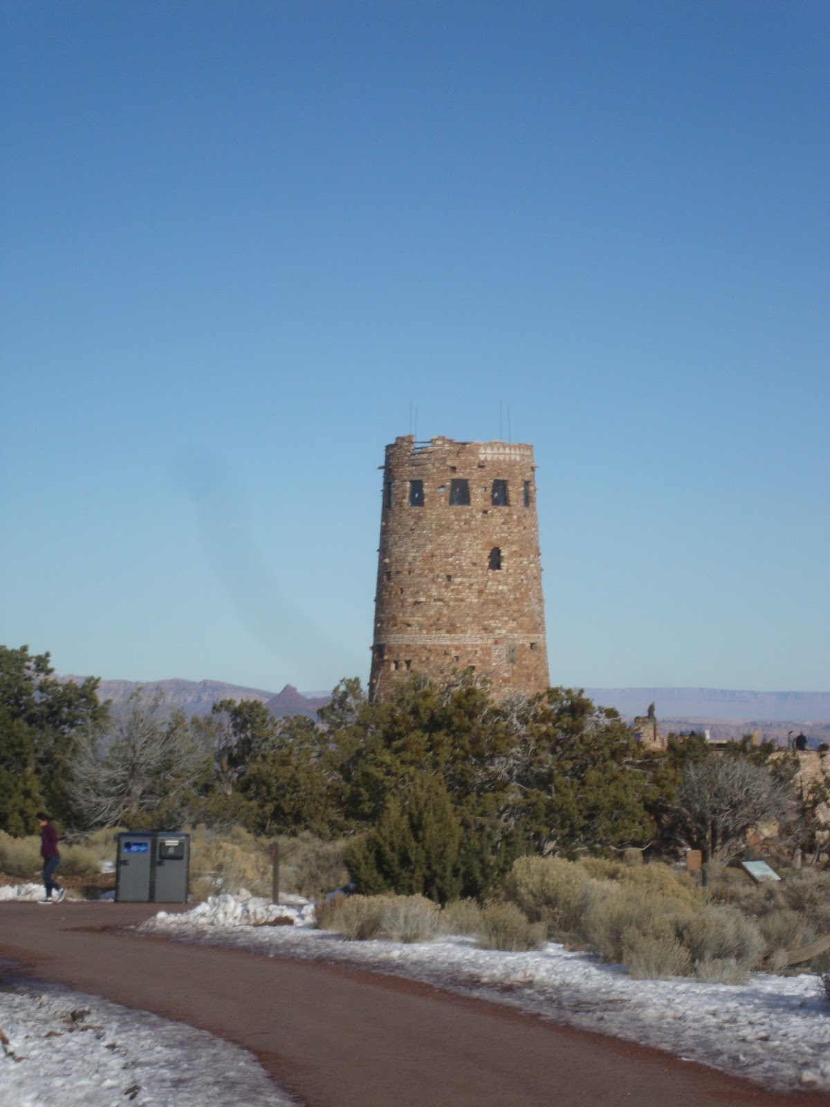
We also did the obligatory trip to the other end of the park, Desert View. Desert View overlooks the point where the Little Colorado River joins the Colorado. The Desert View tower is another example of Mary Colter's ability to design something new that comes out looking really old. One of the nice things about Desert View is there's almost always a Native American artist or musician demonstrating his or her craft. The day we were there a potter was demonstrating her craft and there was a Hopi musician who played the flute. The musician was the grandson of the artist who painted many of the images on the interior of the tower. He gave a really informative talk on the second level of the tower. It was fascinating. Naturally, 90% of the tourists present weren't interested at all in learning anything about either Hopi history or what the paintings represented; they were just interested in going up and down the tower to get up to the top level. It floored me -- the guy's giving a talk, he's got a decent sized group around him who are obviously listening, and the asshole tourists couldn't even shut up for a few minutes as they passed through that level. I swear people are getting ruder and dumber by the day.

Tusuyan Museum
One place where we did escape the hordes briefly was the Tusuyan Museum and Ruins. When we pulled in there about 9:30 in the morning, we were the only visitor car in the parking lot. The typical Grand Canyon tourist, it's abundantly clear, is not real interested in the heritage resources. The Museum was built in the 1930s to house some of the artifacts found in the park. It's located next to the remains of an ancient pueblo. The museum is small but quite interesting. An interpretive trail loops around the ruins; a slightly longer loop has signage explaining how various plants and trees served as food sources or were used in other ways.

Interpretive trail at Tusuyan Pueblo Museum
As usual, there were signs everywhere pleading with people to stay on the trails, don't walk on the vegetation, please don't climb on the ruins, . . . all of which, going by the footprints in the snow, had been ignored. In fact, one of the don't walk on the vegetation signs was bent in a way that suggested someone had recently tried to steal it. The museum may not get the hordes of visitors other sites in the park do, but it's pretty clear it does get the usual high percentage of idiots and asshats. I swear I don't know how the NPS personnel who get stuck working with the public manage to keep smiling. I couldn't do it.

So you say you'd been thinking about visiting (or re-visiting) GRCA but now are having second thoughts? Don't. The park is definitely worth visiting. Just do a little more pre-planning than we did. We did a couple smart things -- we stayed at Yavapai Lodge so were both right within the park and walking distance from the Market Plaza so had easy access to groceries. Yavapai has mini-fridges and coffee makers in the rooms; we couldn't cook hot food but we didn't have to rely on restaurants for ever y meal. We knew about the shuttle and used it. We also did something a lot of people appeared unwilling to do. Grand Canyon Village is laced with walking and biking paths; we didn't see many people walking anywhere other than milling around in the most congested areas. The Kid and I combined the shuttle and walking, although not as much as we probably should have. In retrospect, we should have used the shuttles more. In any case, if you can swing it, stay in the park, either camping or at a lodge. The lodges aren't cheap, but being close to everything eliminates a lot of headaches.

Pueblo ruins at Tusuyan Museum
And, speaking of the lodges, want to pick a good time to visit? Go to the lodges' reservation pages (Yavapai is operated by Delaware North; the others are all Xanterra; there are links on the nps.gov/grca web site) and look for times mid-week when there are lots and lots of rooms available. If you have trouble booking a room, if pickings are slim, that's a sign it's going to be crowded. It's advice I should have followed instead of thinking about saving the Kid one day's annual leave.

Then keep in mind that one of the problems at the park can be too many people and not enough dining out options. Yavapai has a bizarre system in place apparently designed to remove some humans from the equation -- you place your order and pay for it on a computer screen and then get to stand and wait to pick it up just like you would at any cheap fast food place, except it's not cheap. I don't know about the average diner, but if I'm going to pay inflated prices for prime rib, I'd kind of like an actual human to come to the table and take the order instead of dining in what's basically a cafeteria. We ate at Yavapai one time (had an extremely mediocre pizza that was cold by the time we got it), in the restaurant at Bright Angel Lodge once, the food court at Maswik once, and the deli in the supermarket in the Market Plaza once. Bright Angel had good service and the food wasn't bad (although they did make my Monte Cristo sandwich the wrong way)(on the positive side, they didn't dust it with powdered sugar, which is one of the stranger things I've seen done to that particular sandwich over the years), the deli was good, and the food court was better than average for a food court. Prices overall were on the high side, but that's exactly what you expect in a place that's crawling with tourists. Except for the deli, there were long lines and a lot of waiting time every place that served food. In short, pack a cooler so you're prepared if the lines are longer than you feel like dealing with or you're on a schedule where you absolutely have to eat at specific times (e.g., you're an insulin-dependent diabetic). If I had to do it over again, we'd have picked a different week and we would have had more of our own food with us.

Desert View
So would I go back? Probably, but not to the South Rim. Having been there three times now, I think I'd like to see the giant hole in the ground from the other side.

Next up in the road trip reports? Wupatki National Monument.