Showing posts with label tourism. Show all posts

Thursday, November 17, 2016

Scenic Texas

There are definitely reasons to avoid ever driving through the Texas panhandle. I think we found one.

We'd been drivng for awhile down through the extremely skinny Oklahoma panhandle into the northwest corner of the Texas one. Our Rand McNally had a couple picnic tables/rest areas marked along US-54 from Guymon, Oklahoma, to Logan, New Mexico, so we figured we'd stop at one in Texas to stretch our legs and maybe use a restroom. Even if there wasn't one at a picnic area, there is one in the Guppy.
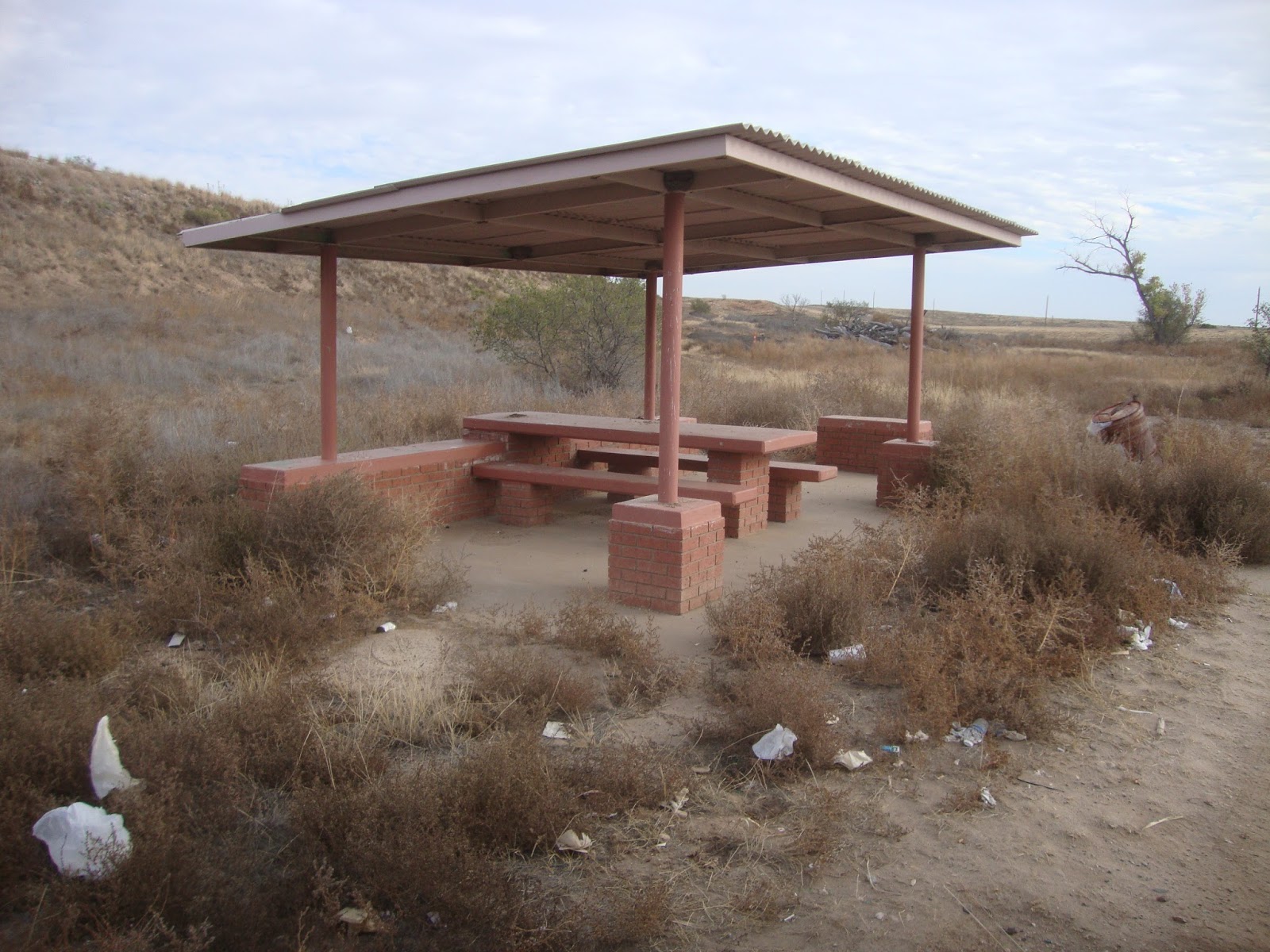
On the positive side, it did have a book on stick with some moderately interesting local trivia. Texas is full of these historical markers; depending on what part of the state you're in, it can feel like they're as common as mile markers. At some point in the past, this spot had actually been a pretty nice rest area. It sits next to a planned river (as the S.O. and I tend to refer to the washes that have water in them about three days out of the year; the Southwest is full of them), it's set off the highway with a nice circular drive in and out, and at one time it had had some fairly nice ramadas with picnic tables. I'm not sure which particular administration in Austin decided "screw rest areas" but it's pretty obvious maintenance for this one vanished from the budget quite awhile ago. This is what you're greeted with now.
Looking on the positive side, I'm not sure just what type of bird decided that ramada is prime nesting territory, but there were definitely lots of birds' nests built from mud around the underside of the roof. We startled them enough that I didn't get a good look before they vanished in a flurry of feathers.

We get tourism advertising from the State of Texas on a regular basis, thanks to having camped at a Texas State Park (Fort Richardson). Somehow I don't think rest areas like this are ever going to make it into the tourist brochures. 

The truly bizarre part is there were still trash barrels with plastic liners in them. Does anyone ever come around to empty them? And if they do, why bother? 

Thursday, November 27, 2014

Another reason to never visit India

India used to be close to the top of my "when I win the lottery" travel list. It's a huge diverse country with amazing historical sites and a fascinating history. I have a friend who teaches south Asian art history and I've occasionally envied him for the time he got to spend in Pakistan and India. Not anymore.

I knew the cities are crowded, dirty, and probably reek, but in the back of my mind there was still a vague "I'd like to go there someday" feeling. Even watching contestants on "Amazing Race" trying to turn cow shit into fuel didn't really discourage me. Everyone knows India is a country of strange contrasts: congested urban centers with modern skyscrapers and cows being milked in alleys, crowded buses and taxis jostling for driving space with ox carts, incredible wealth right next door to appalling poverty. Then I started seeing an occasional article about the public hygiene problems. Turns out the streets of Mumbai and Kolkata aren't just filled with cow shit. There's also plenty of the human kind. For a country that is becoming a global economic powerhouse, India suffers from an astounding lack of toilets. The public pissoirs and water closets that are easy to find in most industrialized countries are astoundingly rare in India. It is apparently a common sight on city streets to see men casually step up to the side of a building to urinate. Any building. I've heard people complain that city streets in New York can smell like piss. I have a hunch you haven't really smelled human urine until you've been to India.

Okay, if the men are pissing against the sides of buildings, just where are people defecating? You got it. In the streets. Maybe not quite as publicly as the dudes marking their territory on the sides of buildings, but pretty damn close to it. Apparently most people wait for the cover of darkness to go out and squat in the gutters, but not all. So the fragrance of India consists of the smell of rotting human waste on top of the cow shit and miscellaneous other animals' crap. I suppose I could live with that, especially as a tourist. It couldn't be any worse than living downwind from a hog farm (or driving through Iowa). Tolerable, if not particularly enjoyable.

And then I read an article about the complete lack of women's rest rooms. Men get to piss against buildings. Women get to hold it. Even workplaces, the factories, office buildings, and call centers where women work have very few toilets. One article described a textile factory that employed hundreds of women but had no restrooms. The women were expected to just refrain from pissing for the entire length of their shift. Unreal. People bitch in this country about being expected to just hold it until their coffee break or lunch, but can you imagine having to wait 8, 9, or 10 hours? Not surprisingly, this lack of places to pee is causing significant health problems for Indian women. It's also contributing to the rape crisis: over half the population of India still lives in housing that lacks indoor plumbing. The women have to leave their homes to relieve themselves and then are victimized when they try to use one of the local toilets or go out to piss or crap in the gutters once it's dark.

It is so bizarre. How can a country that has nuclear weapons also be so fucking primitive that there aren't enough toilets to go around? I can understand a lack of toilets in underdeveloped nations that are suffering from a lack of money or have been wracked by decades of civil unrest, like the Congo, but India? India is the home of a gazillion call centers and is also noted for exporting engineers and doctors to the rest of the world. Then again, maybe that explains why my primary care physician is now living here in Baraga County instead of back in her home country. She's not too thrilled with the long winters here, but at least there's never a problem finding a toilet.

No doubt as a tourist I would be carefully sheltered from the realities of life in India. For sure the hotel rooms would all have bathrooms, so a casual traveler might never really notice the lack of facilities elsewhere. Still, when the lottery winnings roll in, I think I'll plan to visit someplace like Iceland instead. If nothing else, it's cool enough there that if people are pissing in the streets the smell won't be as noticeable.

Wednesday, October 29, 2014

Montauk State Park, Missouri

CCC-constructed picnic pavilion (aka shelter)
This feels a little weird. Usually if I spend more than five minutes in a park I'll do a post. All it takes is a ten minute walk in to see a waterfall and I've got half a dozen photos and several hundred words of verbiage up. Not this time. We've been at Montauk State Park for exactly 4 weeks today and I've yet to do much more than gripe about the fact some guys think Busch Lite cans are flammable. Not one word about the history of the park, where it's located, or the plethora of cultural resources, e.g., numerous structures built by the Civilian Conservation Corps in the 1930s.

Montauk State Park is located in the Missouri Ozarks at the headwaters of the Current River. The river is formed where Pigeon Creek and the discharge from Montauk Spring merge. The Montauk Spring has an impressive discharge rate -- approximately 43 million gallons per day -- so the river is a real river from its start, which is an interesting contrast with my memories of the North Platte in Nebraska. The Platte is called a river as long as it's still in the state, but by the time you get to where it's flowing in from Wyoming you can step across it without worrying about getting your feet wet. But I digress. Montauk Spring is one of those interesting springs that bubbles up through sand. When there is a lot of water flowing through the aquifer, it can look like it's boiling. Missouri's been in drought for several years now so the boiling is now more like a gentle blooping, but you can still see the sand at the spring bubbling as the water flows up through it. The water is amazingly clear.
Fishermen downstream from the ruins of a low water bridge.

Since we arrived here, I've had several people ask me about the origins of the name Montauk. According to the park website, the area was named by settlers from Suffolk County, New York. It may be an old Indian name, as some people guess, but if it is, the Indians were from Long Island. The abundant water from the spring meant this area provided an ideal location for a flour mill. Several were built along the river; most burned down. The Montauk Mill constructed in 1896 survived; it operated for 30 years until the state purchased the land in 1926 and created a state park.

Montauk State Park is one of the oldest state parks in the Missouri state parks system. It is also one of four "trout parks" in Missouri. The other three are Bennett Spring, Roaring River, and Meramec.

The trout parks, Montauk included, are interesting from an organizational perspective because they involve cooperation between two separate state agencies: a cold water fish hatchery is co-located within or adjacent to each park. The hatcheries are operated by the Department of Conservation; the parks are operated by the Department of Natural Resources. Of the four trout parks, Montauk reputedly has the best fishing because, among other reasons cited, the river is managed in a way that keeps it as close to to a natural stream as possible. The park is large enough and the river contains enough bends that there are approximately 3 miles of river along which a person can fish. One section of the river is fly fishing only, but most is open to any lure or bait, artificial and live.
Rearing ponds at the hatchery

Most fishermen (which includes men, women, and kids), however, seem to congregate as close as possible to the upper end. This is despite the fact that when the fish are planted the plantings occur at multiple locations. You know, it's not like they open a door at the hatchery and tell the first 500 fish on any given day to "Go, swim free. You're on your own now, No more pellets; it's time you go looking for lunch instead of having it come to you." Nope. They load the fish into a truck and dump them in at a variety of points along the river. Nonetheless, based on the herd behavior of the people fishing and the way they seem to enjoy being shoulder-to-shoulder upstream from the campground, I'd guess that the fish that get dumped into the river at the locations farthest downstream from the actual hatchery are the ones that live the longest. There's a white board at the Lodge where successful fishermen can record catches they're particularly proud of; I noticed the other day that the most recent entry was an 8-lb trout. Obviously, not all the fish end up in a landing net right after being released.

Looking down the center of loop 2 on a day when the park was full.
There is more to Montauk SP than just the fish, of course. The park sits in a hollow in the Ozarks. The scenery is gorgeous, especially at this time of year. There's an abundance of wildlife. There are hiking trails. The park is lucky enough to have a naturalist who seems to have a gift for presenting interesting programs and connecting with any kids who are listening. The campground is a good one and has a nice playground for families camping with small children. There are numerous picnic tables scattered throughout the park, and there are two picnic pavilions (aka shelters). Two other playgrounds are located near the picnic shelters. It's a great family park.

As for the campground, the sites are almost all large enough that even someone with a leviathan of a Class A motorhome or a super-long travel trailer can park and not feel crowded. Although I've talked with campers who have been coming here since the 1960s who can recall when the campground was basically an open field and access was via the low water bridge shown above, the campgrounds now enjoy mature landscaping and the amenities campers today expect: electrical service and access to a showerhouse. (The only full service sites in the park are the campground host spaces.) The park has two showerhouses, both of which include laundry rooms with coin-operated washers and driers. The campground has four loops, one of which is basic, one has 30 amp electrical service, and two have 50 amp. Construction of a 5th loop is scheduled to begin in 2015. Whoever picked out the trees when they designed the campground loops knew what he or she was doing because there's a variety of deciduous species: maples, river birches, sycamores, sweet gums, oaks, etc., for shade along with smaller flowering trees like dogwoods and redbuds for visual interest.

Campground host site, Loop 2. 
In addition to the campground, there are a motel and rental cabins available for people who prefer more creature comforts (or less work) than a typical RV or tent provides. A number of the cabins were constructed by the CCC in the 1930s, but there are also newer units. The motel (aka The Lodge at Montauk) includes a full-service restaurant, a snack bar, and a store that sells fishing tackle, souvenirs, and a few basic groceries.

Montauk SP shares a boundary with Ozark National Scenic Riverways. OZAR begins where Montauk ends on the Current River. A number of interesting historic sites within OZAR -- the Susie Nicholls farm, the Welch Hospital ruins -- are within a few minutes drive of Montauk, as well as several locations for launching canoes or kayaks if a person is interested in floating the river.

People fishing from the remnants of the other low water bridge in the park.
Overall Montauk is a great place to camp if crowds don't bother you. This park is popular. Anyone coming here during the "on" season hoping to commune in silence with nature is doomed to disappointment. The No Camping Vacancies sign has gone up by the fee booth pretty early each weekend we've been here. During the peak months, reservable sites are often reserved many months in advance, and the first come first served sites tend to fill up remarkably fast. On Fridays and Saturdays RVs will be circling like sharks before noon hoping to see someone in one of those sites pull out. Even the basic sites fill up fast with people who still enjoy tent camping. It's a good thing most campers leave sites clean because when there's maybe a 10-second gap between one camper leaving and another one backing into that space, there's no way the hosts or regular maintenance are going to have time to check the site for trash. The park does hope to eventually complete a back country hiking trail that would include two hike-in camping sites, but that trail's development is probably several years away. In short, the park is awesome, but if you're looking for solitude, look elsewhere.

Monday, October 21, 2013

Another nice Upper Peninsula museum: Jake Menghini

This past Saturday the S.O. and I drove down to Norway, Michigan, to attend a meeting of the Northland Consortium. The consortium is a loose organization of local historical societies and museums located in the central and western U.P. and northern Wisconsin. Meetings rotate around the region and generally feature a couple speakers in the morning and a field trip to the host museum after lunch. The morning meetings can turn kind of strange -- at this year's meeting I was treated to a lecture about how local historical societies and museums can't manage to do web sites or have Facebook pages because we geezers are all too technologically illiterate to figure out how the Intertubes work -- but the field trip part of the day is usually fun.
The Jake Menghini Museum in Norway began the way a lot of small town museums did: the core collection came from a hoarder collector who kept his stash in an old log building that he eventually referred to as a museum. At some point the city of Norway acquired the collection and decided to build a new museum on the edge of town at what had been the Anton O'Dill farm.
Francis turbine from the city of Norway hydroelectric plant. The museum director said it just showed up in front of the museum one day. She said one of the drawbacks of being owned by the city is that city workers will occasionally drop objects off with very little advance warning. She's lucky if it's just city workers: we have odd objects dropped off by the general public all the time with no advance warning and it's rarely anything as nifty as a reaction turbine. 
The museum is fairly new building and is large enough to have multiple life-size dioramas. I had some quibbles about some of the displays, but then I always do. 
For example, the room shown below cries out for a different presentation of the basket casket. I'd have placed it on a table and had a mannequin laid out in it so you'd know immediately what it was instead of kind of wondering just what the oversize object standing in the corner is. 
On the other hand, none of the spaces is very big. If they had actually placed it on a table, there wouldn't have been much open floor space left. I did, of course, suffer some serious object envy over that basket casket. As far as I can tell, the only things the local funeral homes have given the Baraga County museum are a notebook listing all the funerals held there over a 50-year time period and a couple vases. 
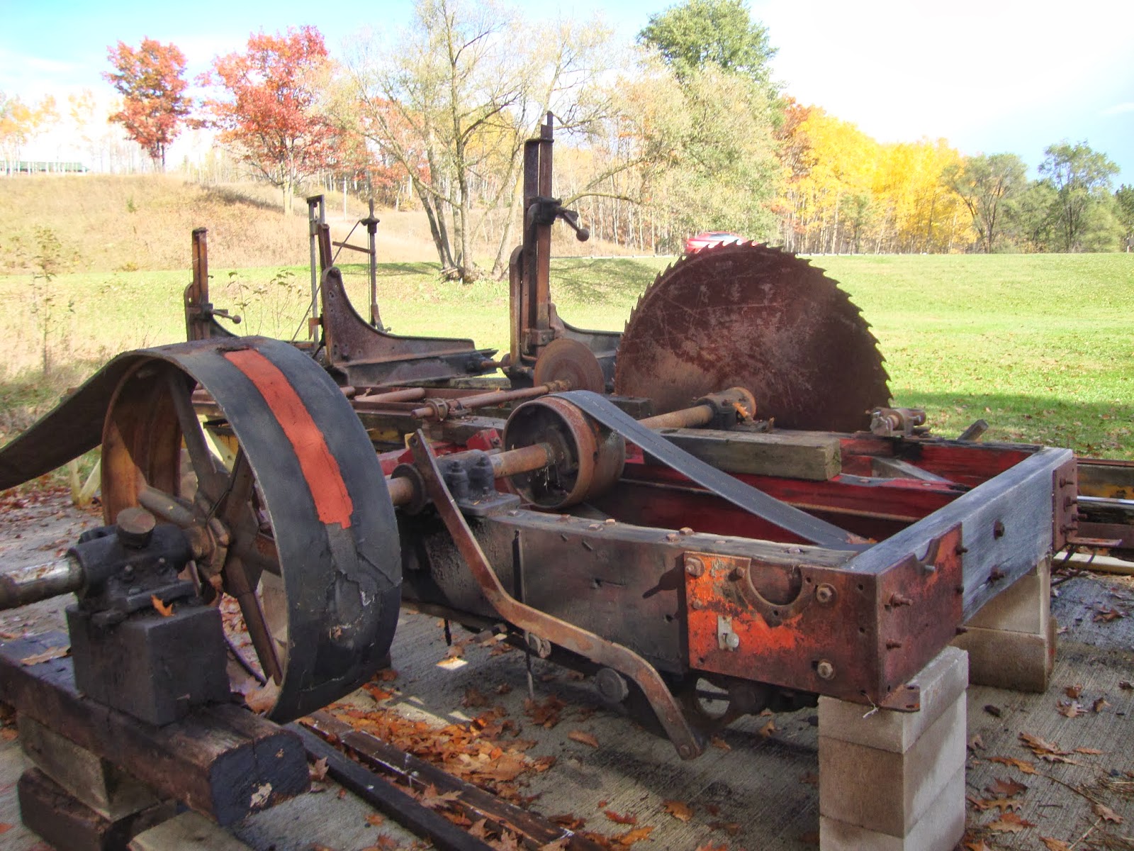
There was, of course, the obligatory space filled with miscellaneous clutter: sad irons, various cooking gadgets, odds and ends of tools, and what to me looks like the scariest juicer I've ever seen. The thing looks like a prop out of an early episode of Dr. Who. The museum is lucky enough to have a fair amount of land so has plenty of space for outdoor exhibits, including their latest acquisition, a sawmill:
The S.O. immediately began waxing nostalgic. He's familiar with this type of sawmill. He worked at a sawmill that used this same type of set up. He pointed out one mistake they've made in setting it up. If they wanted to be truly accurate, they need to add more track to the left of the saw in the photo above. 
The museum volunteers were making a verbal mistake, too, when they talked about the sawmill. They kept referring to it as "steam powered." Well, I'm not much of a mechanic, but when a device is labeled "diesel," I tend to believe that's what it is. Perhaps the original power source was a steam engine, in which case the volunteers need to make that clear in their descriptions. 
The museum does plan to put a pavilion over the sawmill to protect it from the elements. The other structure at the museum is a restored farmhouse. It's set up as a house museum, i.e., it's relatively uncluttered and an effort has been made to have it look as though people are still living there. The overall impression is early 20th century, but it hasn't been strictly curated to limit it to any particular decade. The kitchen, for example, includes a number of items that are clearly mid-20th century or later, but that's another minor quibble. Overall it's very nicely done and well worth visiting if a person happens to be passing through Norway on a day when they're open. Like most of the U.P. museums, they're only open in the summer and then only three days a week. And, despite the face*palm moment at the morning meeting when the subject of having an online presence came up, the Jake Menghini Museum does have a website:  http://www.norwaymuseum.org/. 

Sunday, October 13, 2013

I wonder what else the county is hiding?

The S.O. and I decided to play tourist the other day. Every so often this summer someone from out of state would wander into the museum and ask me about a place in Baraga County that I had to admit quite honestly I knew absolutely nothing about except maybe its general location. Baraga County is big (1,068 square miles) and mostly rural. There are lots of places in the county where I've never been and probably will never go so I don't view the fact I don't have personal knowledge of every scenic waterfall or interesting building as much of a problem. Still, I got asked about Pointe Abbaye often enough that my curiousity was piqued.

Pointe Abbaye is the peninsula to the northeast of L'Anse, although when people say Pointe Abbaye they're often referring to the actual tip of the peninsula, a site that is about 25 miles from L'Anse and is accessed by roads that become increasingly more interesting to drive. You know, the blacktop ends, the two lanes of gravel start shrinking down to one lane of dirt, and pretty soon you're asking that age old U.P. question: county road, logging road, or snowmobile trail? Turns out it is definitely county road all the way, as the photo below illustrates. If you look close, you can see that the fire number on the sign says "Pt. Abbaye Rd." It also makes it clear (especially when you look at a map) just where Pointe Abbaye got its name -- it's bastardized French reflecting the fact it's the point between two bays: Keweenaw and Huron.
And why is there a fire number you may ask? Well, it turns out that the 258 acres at the tip of the peninsula are a county park, and it has structures. Structures call for fire numbers. Granted, the two buildings consist of a pair of pit privies, but they are buildings nonetheless. They're actually rather well maintained pit privies -- they were clean. In addition, the parking lot was mowed, and the trash had been emptied recently. 

The sign indicated there were three hiking trails. We opted for the one out to the tip. It didn't actually look much like what I think of as a hiking trail; it was definitely a two track road with pretty recent tire tracks. When we got to the tip we found the reason for the fresh tire tracks: several guys fishing who had driven in and parked close to where the dirt disappears and the tip of the peninsula turns to bare rock. 
Considering that it was a Thursday in October and the park isn't particularly easy to get to, it was remarkably busy. Besides the fishermen, there were a couple of guys from Illinois who were probably going to camp for a night or two -- we met them walking out as we were walking in, and shortly after that they drove their car in from the parking lot to a rustic camp site off that looked to be about 150 feet or so off the trail and right on the lakeshore. Then, when we got back to the parking lot, we discovered another car with an out of state plate had arrived. The driver of that one asked if anyone was camping. We said yes, but they decided to check out the site themselves. I got the impression there were a couple other spots that were suitable for tent camping, but the place the first car had driven in to was probably the best. 
I asked the S.O. if he had known there was an actual park at Point Abbaye. Nope. Not a clue. I certainly didn't know it. There's nothing in the tourist literature we have at the museum, which includes a summer fun guide published by the local Tourist & Recreation Association to tell you it's there. The Backroads & Tourism Map put out by the Tourist & Recreation Association does include Pointe Abbaye as a place of interest but just says "An unmatched view of the Huron Islands and the Huron Mountains." Not one word about it being a park. If you Google "parks in Baraga County" a decent list comes up, but Pointe Abbaye isn't on it. There is also no signage whatsoever until you actually pull into the parking lot. The only thing that keeps you pointed in the right direction is seeing the road sign for Pointe Abbaye Road at the intersection with Townline Road. After that, it's a matter of just sticking with what appears to the most traveled road as it winds along the peninsula. 
When I Googled Point Abbaye I did learn that last year the county wasted money on having U.P. Engineers and Architects draw up a development plan for the park. Obviously, this means that they do occasionally admit publicly that the park exists. Not surprisingly given the penchant of consultants to always think big, the proposed plans had a price tag of several hundred thousand dollars because they included building a power boat launch in addition to creating about a dozen rustic camp sites. Idiots. The two -- power boats and tent camping -- are mutually contradictory. A kayak and/or canoe launch would make perfect sense and cost almost nothing. People who kayak also like to tent camp. Power boaters? Not so much, plus the noise from power boating would really trash the quiet atmosphere the park has now. It's so far removed from everything else that the only noises you hear are natural ones. I have no idea whatever happened with the development plans, but my hope would be that anything they do to Point Abbaye would be low key: put in a picnic table or two, maybe clear a couple more campsites along the lake shore, and maybe, just maybe, put up a road sign or two to let people know the park actually exists.  

Monday, September 30, 2013

Local attractions: Covington Historical Museum


Yesterday I finally got around to checking out one of the other museums in Baraga County, the Covington Township Historical Museum located -- where else? -- in Covington. It's housed in the former township hall, a building that dates back to the early 1930s. They were holding their annual end of the season fall festival; they won't be open again until next summer except by appointment. As a person who thinks a lot about the National Register of Historic Places, I walked into the building and thought, holy cow, why isn't this place listed?! Other than stuffing the museum into it, I don't think the building's changed a whole lot since its original construction.
There have been some minor modifications to the building, but nothing major. The biggest change to the interior was the addition of the balcony along one side after the museum was established in the late 1990s. It was built to provide additional exhibit space, but is the type of modification that falls into the "adaptive re-use" category and no one really cares about anyway. The National Register gate keepers obsess about exterior appearances; having an unchanged interior is basically a bonus. Of course, the building isn't going to remain eligible much longer: township supervisors plan to do vinyl siding and replacement windows in fiscal year 2014. No doubt the window replacement job will include blocking a few off, too, in the name of energy efficiency. The historical society itself seems split on the issue: one fellow told me he'd really like to see the building listed and is opposed to the window replacement as currently planned; another member said she doesn't care as long because what counts is what's in the building and not what it looks like on the outside. An understandable sentiment, although not one I necessarily agree with. I did tell her that vinyl is really poor choice for a lot of reasons -- if they're going to do new siding, they need to go with a material that doesn't burn -- but in the end, it's up to the township board. They still own the building. 
In any case, on the main floor under the balcony the Covington Historical Society has set up spaces with specific themes: there's a workshop space with various tools on display, an office/school space, and a kitchen/dining space. There is the usual incredible clutter, the embarrassment of riches, many small local museums suffer from: people give you things so you feel obligated to display it all, which results in a space that doesn't really represent any specific era and can be a little confusing. The stove top shown above, for example has at least three meat grinders, two different types of irons, an old lunch pail, a double boiler, and a meatball maker all kind of jumbled together. A professional curator would probably suggest some selective editing was in order. On the other hand, most of the items are tagged: they have labels with the item's name and where it came from, i.e., "Donated by . . . ." People with roots in the Covington area can walk in and go, wow, there's my grandmother's rolling pin. We do something similar at the museum in Baraga, but it was pretty clear the Covington folks have a much better handle on inventory and keeping track of who gave what than we do. I was more than a tad envious of their organizational skills. 
I am moderately astounded I didn't spot the strange green thing when I was taking photographs; it's pretty bizarre as a partial object. Is it a lamp? An objet d'art? Who knows. . . but it looks like it should glow in the dark.  
Up on the balcony, the space is also organized loosely by themes. There's a nursery space, a living room, an area devoted to sports, and a space that is primarily bridal: there were multiple wedding gowns spanning about 80 years of Covington history. The oldest dress appeared to be a flower girl's dress from the 1920s; the oldest bridal gown was from 1940. 
The Covington museum is also blessed with a full basement. The building has a high foundation, so there's good natural light. They have a number of large items displayed down there, including the laundry equipment shown above. I have a minor quibble with the display: I'd have set it up in chronological order so you could see the progression from the copper boiler on the stove to wash tubs on a stand with a wringer to that amazing wringer washer with attached rinse tub to the more modern wringer to a 1990s washer, but maybe that's just my OCD kicking in. 
There is also, of course, a display of logging tools that includes these ancient power saws. Once again a little bit of museum envy crept in. Our county museum has a zillion buck saws and cross cut saws, but no one has seen fit (yet!) to donate a decent antique chain saw. Then again, we don't have one of these either:
The Covington museum is open seasonally, June through September, and is located one block west of US-141 in downtown Covington, Michigan. 

Wednesday, July 31, 2013

We go Green Bay

We spent a few days in Green Bay, Wisconsin, recently. The attraction for the S.O. was the annual Packers shareholders' meeting; I just kind of tagged along. I did discover, however, that Green Bay has a really nifty botanical garden.
It covers 43 acres and has a nice network of paths, walkways, and hiking trails that allow a person to amble through a variety of settings and over varied terrain. There are one or two small formal gardens, but overall the plantings were more along the lines of what I'd label as a cottage garden.
I believe this what people mean when they say "formal" or "Italian" garden: wide pathways and foliage tightly controlled.
I much prefer the informal:
Among other things, it's a lot easier to skimp on weeding when you have masses of plants jostling up against each other. I'm  not a particularly ambitious gardener, so seeing that sow thistle had managed to sneak in amidst the bee balm and lilies was oddly reassuring. I'm definitely not the only person who misses stuff when pulling weeds.  

A few more photos:

There's even a folly. 

Unbelievably gaudy (and ugly) frog in the children's garden area.

There some amazing oriental lilies. The plants were the tallest I've ever seen and the blossoms were huge.


Comfort station
The gardens also had a wonderful assortment of day lilies and hostas. Neither is my favorite type of ornamental plant, but both are nicely reassuring in that once they're planted, nothing seems to kill them. Even deer ignore day lilies. It's good to know that there really are a gazillion varieties, which means that even if nothing else will grow, you can still have some variety in the flower beds.

Sunday, June 9, 2013

Seeing this felt good

Back a few years ago, in about 2000, I got asked to serve as a local historical society's representative to a county-wide committee to work on a project that the Tourist and Recreation Association had thought up. The plan was to publicize some of the county's cultural and historical attractions. It was an interesting experience. Our county has about a dozen small groups devoted to various preservation or cultural efforts, most of which focus on just one thing, e.g., preserving a one room schoolhouse, and a few with broader goals. The representatives to the committee were a mixed lot. People definitely are strange. There were some folks who seemed to think historical knowledge is a private good and weren't real keen on sharing -- an odd attitude, to say the least. If you believe the history is important enough to form a local historical society to preserve it, shouldn't you also want to make sure as many people as possible have a chance to learn it?

Overall, though, we managed to reach some consensus and came up with a list of possible sites to include on a map. With help from the Copper Country Council for the Arts, the group put together a grant application that succeeded in getting a decent amount of funding from the Michigan Council for Arts and Cultural Affairs. It wasn't a huge amount, but, along with a few bucks kicked in by each of the participating local groups, it was enough to help pay for an individual sign to be posted at each site and for three large signs to be erected at each of the highway rest areas (Tioga Falls, Canyon Falls, and near the community of Keweenaw Bay) that tourists are likely to stop at. It's been about twelve years since this sign went up at Canyon Falls. There's some minor wear and tear, but overall it's still looking good. So are the signs at each of the heritage sites. It is remarkably satisfying to look at the end product of something designed by a committee and realize that it actually was worth doing.

The hardest part of this project, incidentally, wasn't getting a dozen people to agree on which sites should be prioritized and it wasn't finding the funding. It was getting the Michigan Department of Transportation to agree to the signage at the rest areas. If it's not their idea, they don't want it there.

If anyone feels like stalking us, the S.O. and I live fairly close to the number 7 on the map.

Tuesday, June 21, 2011

George Rogers Clark National Historical Park

George Rogers Clark
"George Rogers Who?" you ask? Revolutionary war hero whose victories occurred in places like what is now Vincennes, Indiana?! Pshaw. Everyone knows all the important Revolutionary War stuff happened a lot farther east, like in Massachusetts and New York.

Back when I worked for the Park Service, this was one of the parks that I got told we didn't bother going to: it's small, its main claim to fame are a battle and a military commander no one can remember, and it got nominated for status as a National Historic Landmark based on the architecture of the monument (see below), not for its association with Clark (see above). It fell into the mystery category, also known as which politician pulled strings to get this one into the system? (There are a number of units in the system where employees regularly wonder just why they're being managed by NPS and not by a local township. You know, nice, moderately interesting, but are they really, truly of national significance? George Rogers Clark actually comes closer to that significance standard than some better known places.) I was moderately curious about the place, but not curious enough to push my boss into sending me there, especially when the park superintendent at the time wasn't particularly interested in having anyone from the inventories do a field visit. I am, however, always willing to check another park or two off on the life list, so decided to follow US-41 down through Indiana instead of sticking to Interstate highways.

George Rogers Clark monument
My first thought was, wow, this thing bears a remarkable resemblance to Warren G. Harding's tomb, although Harding's tomb has more columns and isn't domed. I guess all the massive-monument designers in the early 20th century were working from the same play book. The interior does have nifty murals (a couple are partially visible behind the Clark statue) and some interesting details:
Decorative architectural detail
What, I wonder, is the symbolic significance of having what appear to be bronze vent covers that look like dragons? And why the marble bench that goes all the way around the interior? Were visitors expected to come in, sit down, and stare worshipfully at either the statue of the Great Man or the murals depicting the key events in Clark's part in the War? Maybe I should have grabbed a park brochure. . .  I did quiz the interpretive ranger (or, more accurately, I'm thinking, the seasonal visitor use assistant; based on the levels of knowledge he could muster up, I don't think he'd quite merit the title of park guide), but he was as clueless as I was. Who was the architect? Did not know. When was it built? No clue. Why does the exterior look like a drum? Ah. . . . ah. . .  Get a lot of visitors? Er. . .um. . . I guess. In the world of resource education, the nice young man had a long way to go. There was a fair amount of decent signage explaining the content of the murals, but not much that provided information on the structure itself.
Francis Vigo, stuck with his back to the river and staring at the monument for all eternity.
The park is nicely situated in downtown Vincennes, right on the river, and does include a few other minor items, like this statue of Francis Vigo. I'm not sure what he did to merit a statue, but Indiana did name a county after him. I also thought the Lincoln bridge was lovely -- it looked positively dazzling, much whiter than it photographed:

I'm not going to question the importance of Clark's contributions to the war effort -- he defeated the British in two decisive battles on the western frontier, and as a result the colonies got the Northwest Territories (now Michigan, Ohio, Illinois, Wisconsin, and Minnesota) as part of the peace settlement. It's history worth remembering -- and maybe so is the fact that Clark lived out most of his life as a failure. He was a war hero in his 20s, turned into a drunk in his 30s, and spent the remainder of his life (he died in 1818, almost 40 years after his glory days in battle) surviving on the generosity of various family members. Is there a moral there? Who knows.

Definitely a cannonball park
If a person happens to be near Vincennes, George Rogers Clark NHP is worth a visit. I'm just not sure how to define "near."

Thursday, January 1, 2009

A restaurant review, sort of

Or, if the book is fiction how can the Whistle Stop Cafe be real? Especially when Fannie Flagg is from Alabama and set her novel not far from Birmingham? Those were the questions I found myself thinking, if not actually asking out loud, when the Younger Daughter asked if we were close enough to the Whistle Stop Cafe to go have lunch there. Turned out she knew it was a real place because co-workers back in Texas told her they ate there almost every day while detailed to the Oconee National Forest a year or two ago.
So I Googled it -- and sure enough, there it was: Whistle Stop Cafe, Juliette, Georgia, complete with fried green tomatoes on the menu. Younger Daughter had never had fried green tomatoes, Fried Green Tomatoes is one of her favorite movies, and Juliette is a reasonable driving distance from Atlanta.

Answer to why the Whistle Stop is in Georgia and not in Alabama: it's where the producers chose to film part of the movie. They found a milltown (Juliette) in the middle of rural Georgia to serve as the set, leased a building that was being used as an antiques store to function as the Whistle Stop Cafe, and inspired the owners of the building used as the Whistle Stop to actually run it as a restaurant once the movie wrapped and left town. The surprising thing is that the movie came out 17 years ago, and the Whistle Stop is still going strong.

So how was the food, you ask? Edible, more or less. We did the fried green tomato appetizer, of course, the tomatoes being one of the reasons for going there to begin with. Six Feet Under in Atlanta does them better. The S.O. had the blue plate special, which wasn't. The chalkboard described the cooked-to-the-point-of-qualifying-as-jerky pork chop as "stuffed," but the last time I checked a cookbook dumping a small ice cream scoop's worth of StoveTop and gravy on top of a paperthin porkchop didn't count as stuffing it. (The stuffing may have actually been made on site rather than pre-fab, but there was nothing noteworthy about it. The S.O. described it as "basic.")

Younger Daughter and I both tried the pulled pork barbecue, she got a side of onion rings with hers, I opted to go for the cheaper version with chips. Again, nothing special, although there was a generous amount of dead animal flesh heaped on the bun -- and the sauce served with it was quite good.

According to Tammi's co-workers, the Whistle Stop serves great pies and other desserts. We did see some amazing looking desserts carried past our table. Unfortunately, after the barbecue we weren't up to attempting any ourselves (too full -- the barbecue wasn't the best I've ever had, but it was definitely edible).

Bottom line: nifty atmosphere, great service, so-so food, reasonable prices. If we're down that way again, we'll stop to try the pie but will pass on the blue plate.

Juliette's other attractions include the usual antiques shop, a couple gift shops, another cafe or two, and motorcycle museum housed in the old Juliette grist mill. The motorcycle museum is open only on weekends. Juliette's on the way to the Jarrell Plantation State Historic Site, which we didn't know existed until we decided to go to the Whistle Stop but enjoyed touring once we knew it was there.