Everyone who visits the Big Island of Hawai'i tends to visit the National Park, the one with the active volcano. I always wonder how many tourists also get to the three smaller units of the National Park system that cluster along the coast, two north of where we were staying in Kailua-Kona and one that is south. They're all different and they're all interesting.
Pu'ukohola Heiau NHS is on the northwest side of Hawai'i near the modern town of Kawaihae. It is the site of the last traditional Hawaiian temple built and was constructed by Kamehameha I after hearing a prophecy that if he built a temple to the war god on Whale Hill he would succeed in uniting the islands under one leader, himself.
The temple is constructed of loose laid volcanic stone, no mortar. According to records -- and there was actual documentation from multiple sources; by the time Kamehameha was building the temple Europeans were visiting the islands -- the rock was moved from where it was quarried (collected) many miles away by a human chain of warriors loyal to Kamehameha. One gets the impression from the descriptions that it was similar to a bucket brigade. One guy would pick up a rock, carry it a short distance and then hand it off to the next dude in line. Like a relay race of sorts, except instead of batons they were passing along boulders.
The temple platform is huge, a massive structure on top of the hill. Unfortunately, on the day we visited the trail that leads to the top of the platform was closed. We were disappointed, of course, as the view from up there must be amazing. Other tourists were also disappointed and complained rather loudly about missing out on whale watching. The site is known as Whale Hill because it has always been a great location for seeing whales (humpbacks and others) come in fairly close to shore. Humpback whales apparently migrate to the area around Hawaii, Molokai, and Lanai every winter to give birth. We saw no whales from a vantage point along the trail that parallels the shore, but then we didn't stop at the park expecting to.
The Visitor Center at the park struck me as being a distinctly Mission 66 architectural style. I could be wrong. Both the Center and the restrooms building were built using volcanic rock, which makes perfect sense considering the stuff is everywhere. The Visitor Center is quite nice and, despite being fairly small, has an interesting display area with information on Hawaiian history. The restrooms building was closed for repairs/renovations/something, which definitely was not good. The porta-johns meant to substitute for it were, to put it mildly, disgusting. The contractor was apparently failing to keep them pumped out as often as they required.
We discovered after the fact that we missed one nifty feature of the park: the John Young home. Young was an Englishman who was shipwrecked in the islands and became a good friend and adviser to King Kamehameha I. He married the king's niece, became governor of the island of Hawaii, and his granddaughter, Emma, became Queen when she married Kamehameha IV. His home was the oldest European style building in the islands; today the site is basically a ruin with interpretive signage. It's located on the other side of the highway from the entrance to the main part of the park. We managed to miss signage for it as we continued on our way north. Moral of story: always read the entire park brochure before leaving the park.
Random thoughts about roadside art, National Parks, historic preservation, philosophy of technology, and whatever else happens to cross my mind.
Showing posts with label playing tourist. Show all posts
Wednesday, April 22, 2020
Sunday, January 26, 2020
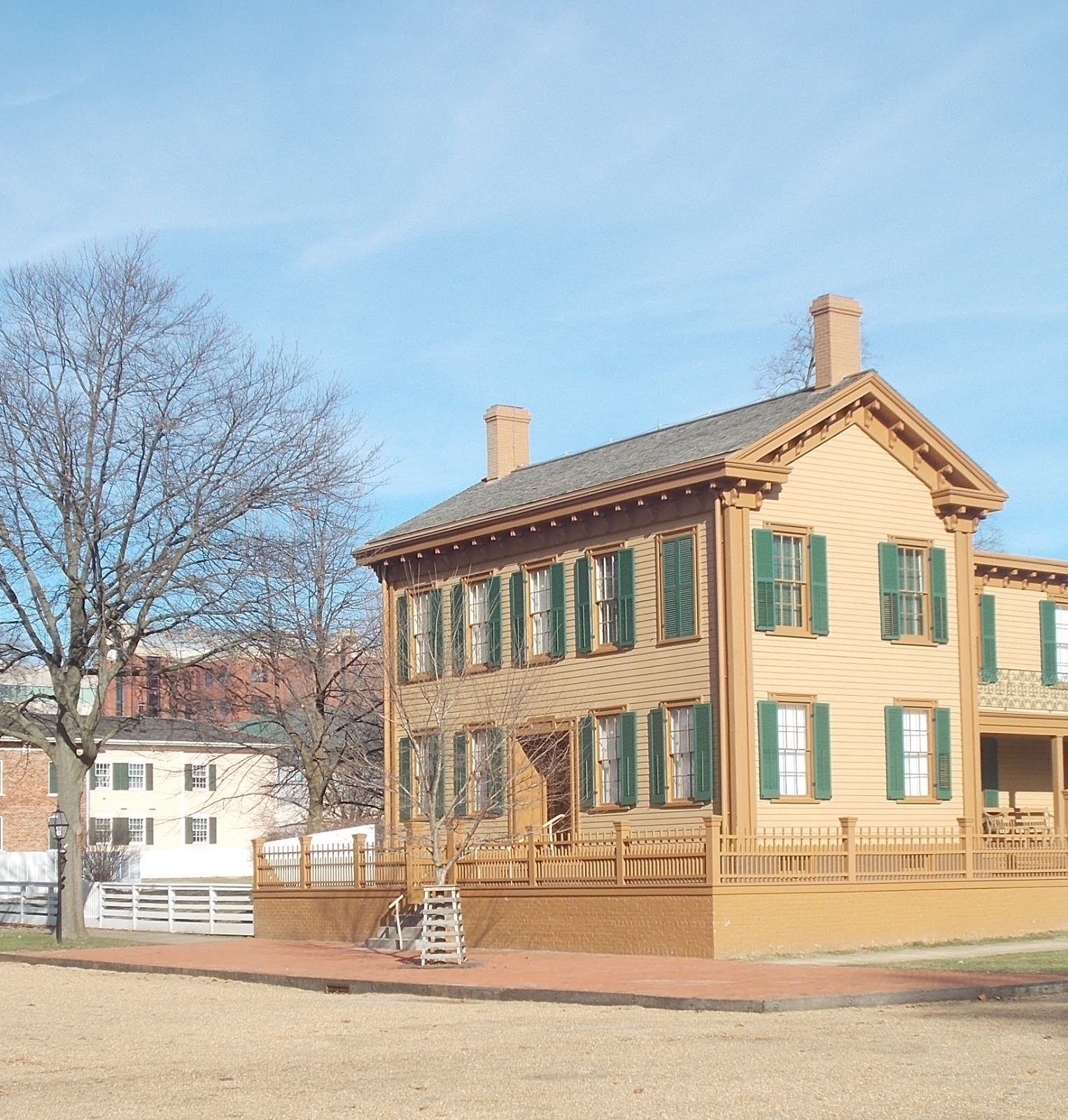
Lincoln Home National Historic Site
The Lincolns bought the house in Springfield shortly after Abe married Mary Todd. It was where all of their children were born and where one of them died. It was very much Lincoln's home. He planned to return there after he finished his term (or terms) as President. When he bought the house in the 1840's it was a modest one-and-a-half story house. As both his income and his family increased, he hired a contractor to expand it to the full two-story house that exists now.
| The small tree with the white cage is the one that is periodically replaced. |
One of the cool things about Lincoln Home is it's not just the house. The park includes property on four blocks. A number of houses that existed when Lincoln lived in Springfield have been restored to their 1850's exterior appearance. Some are used for exhibit space, some are utilized for park offices, and some are leased. When I visited the park for work in 2006 Senator Durbin had an office in one of the houses. From the sidewalk the building looked like all the other 1850's structures. Access and parking for staff was from the alley behind the building.
| The Dean House. It's used for exhibits. |
Sunday, July 8, 2018
I cling to the strangest things
I have days when I wonder if I qualify as a borderline hoarder. I hang on to the strangest stuff. Like most people these days (or so I assume) we have a plastic bags stash. In fact, we have two: one for the usual plastic bags you get from the local supermarket or Target and one for the slightly smaller and flimsier bags that come from Family Dollar or Dollar General. The small bags are good for the small wastebaskets in the house; the regular bags fit the bigger burnable trash can.
So after taking the trash out the other day I reach into the bag stash to get a fresh bag for the trash can. And then I discover I don't particularly want to use the bag that made it to the top of the pile, at least not yet. It's like in the world of throwaway plastic bags, it's a keeper. Why is it a keeper? Because I'm unlikely to ever get another. The bag, pictured above, is, of course, from Arizona, but not just any part of Arizona. It's from the Bashas' market in Chinle. How likely, I ask myself, are we to ever shop at that particular Bashas again?
Actually, the odds aren't that bad. Chinle falls almost exactly midway between where the Younger Daughter lives in southern Arizona and where my mother and sister live in Colorado and sits on the shortest, most logical route, US-191. We've been through Chinle three times in the past 18 months; odds are we'll be going through there again. And if we have the Guppy we'll be camping. If we're camping, we'll probably go to Bashas. Even if we're not, it would a logical place to stop to pick up snacks or drinks.
And if we go to that Bashas, I'll once again marvel at the meat case and wish I liked mutton. You know, in the typical supermarket if you find lamb or mutton, it's in small discrete pieces neatly sealed in plastic. Little tiny lamb chops that are almost too cute to cook. Leg of lamb that was shrink wrapped in New Zealand. At the Chinle Bashas, however, there is no doubt you're looking at disassembled sheep. Not surprising, given that the supermarket is in the heart of the Navajo Nation, but a little disconcerting when you're used to seeing meat that's been packaged in a way that makes it easier to ignore the fact it used to be a live animal.
As a side note, shortly after we'd been through Chinle with the Guppy and had camped at the Cottonwood campground that's inside Canyon de Chelly Natonal Monument I read a review of the campground on a website. The person had been there about the same time we had and laid it on thick about "if you come, be sure to stock up on groceries in Holbrook or Winslow because there is no supermarket in Chinle!" Holy wah. How does a person fail to find a close to brand new modern supermarket that sits right on the major north-south highway through town? When we were there we figured out pretty fast that any town big enough to have multiple major chain hotels (Holiday Inn Express, for example), chain restaurants (Denny's, Burger King), gas stations, and that sits next to a popular tourist attraction (Canyon de Chelly) is going to have a grocery store of some sort. And it did: Bashas.
So what's the moral of this rambling on about plastic bags and travel? I need to let the S.O. be the one who deals with putting a fresh bag in the trash can. He doesn't care where any of the bags came from as long as there are no holes in the bottom.
So after taking the trash out the other day I reach into the bag stash to get a fresh bag for the trash can. And then I discover I don't particularly want to use the bag that made it to the top of the pile, at least not yet. It's like in the world of throwaway plastic bags, it's a keeper. Why is it a keeper? Because I'm unlikely to ever get another. The bag, pictured above, is, of course, from Arizona, but not just any part of Arizona. It's from the Bashas' market in Chinle. How likely, I ask myself, are we to ever shop at that particular Bashas again?
Actually, the odds aren't that bad. Chinle falls almost exactly midway between where the Younger Daughter lives in southern Arizona and where my mother and sister live in Colorado and sits on the shortest, most logical route, US-191. We've been through Chinle three times in the past 18 months; odds are we'll be going through there again. And if we have the Guppy we'll be camping. If we're camping, we'll probably go to Bashas. Even if we're not, it would a logical place to stop to pick up snacks or drinks.
And if we go to that Bashas, I'll once again marvel at the meat case and wish I liked mutton. You know, in the typical supermarket if you find lamb or mutton, it's in small discrete pieces neatly sealed in plastic. Little tiny lamb chops that are almost too cute to cook. Leg of lamb that was shrink wrapped in New Zealand. At the Chinle Bashas, however, there is no doubt you're looking at disassembled sheep. Not surprising, given that the supermarket is in the heart of the Navajo Nation, but a little disconcerting when you're used to seeing meat that's been packaged in a way that makes it easier to ignore the fact it used to be a live animal.
As a side note, shortly after we'd been through Chinle with the Guppy and had camped at the Cottonwood campground that's inside Canyon de Chelly Natonal Monument I read a review of the campground on a website. The person had been there about the same time we had and laid it on thick about "if you come, be sure to stock up on groceries in Holbrook or Winslow because there is no supermarket in Chinle!" Holy wah. How does a person fail to find a close to brand new modern supermarket that sits right on the major north-south highway through town? When we were there we figured out pretty fast that any town big enough to have multiple major chain hotels (Holiday Inn Express, for example), chain restaurants (Denny's, Burger King), gas stations, and that sits next to a popular tourist attraction (Canyon de Chelly) is going to have a grocery store of some sort. And it did: Bashas.
So what's the moral of this rambling on about plastic bags and travel? I need to let the S.O. be the one who deals with putting a fresh bag in the trash can. He doesn't care where any of the bags came from as long as there are no holes in the bottom.
Sunday, April 22, 2018
Bent's Old Fort National Historic Site
Bent's Old Fort is a National Historic Site associated with the Santa Fe Trail. When the S.O. and I planned a road trip to Arizona to visit the Younger Daughter, we didn't set out to do an Auto Tour of the Santa Fe Trail but that's the way it worked out. The last time we did the drive, we got on to US 54 in eastern Kansas and followed it down into New Mexico. It was not a fun jaunt across the Sunflower State. Between dropping a drive shaft from the Guppy and losing a wheel bearing on the tow dolly, I was nervous about taking the exact same route, like maybe the highwat was jinxed. I had no desire to see what might fall off my car somewhere in the middle of nowhere -- and there is a lot of nowhere along US-54.
Of course, there was also a lot of nothing along US-50 in Kansas, but at least nothing fell off the car
The Santa Fe Trail auto route does not follow US-50 in eastern Kansas -- it's a little farther north, along US-56 -- but out by Dodge City the highway and the original trail actually follow the same route, more or less, for quite a few miles. There are numerous historic markers, although no major sites until you get into Colorado and Bent's Old Fort a few miles east of the city of La Junta. Bent's Old Fort is a National Historic Site associated with the Santa Fe Trail.
The fort is an interesting example of a time period in the National Park Service that's unlikely to ever be repeated: the era of reconstruction and replication. NPS went on a rebuilding binge in the 1960's and 70's; a combination of lack of funds and a change in philosophy since then means the preferred approach now is to stabilize whatever ruins remain and put up markers showing where stuff used to be. Fort Bowie in Arizona is a good example of the latter approach. Bent's Old Fort is a total reconstruction dating from the tail end of the rebuilding boom.
The National Park Service got lucky with its reconstruction of Bent's Old Fort. Reconstructing former military installations, like Fort Learned in Kansas or Fort Union Trading Post in North Dakota, was fairly easy. The U.S. Army was a firm believer in standardization. If you've been to one 19th century military post, you have basically been to them all. The enlisted mens' barracks, the officers' quarters, the post hospital, the overall layout of the post, you name it. Standard plans across the country. The only thing that might vary is the building material (in the Southwest, for example, the Army used adobe bricks instead of wood frame construction). Bent's Old Fort, however, was privately owned. There was no standard plan involved. So how do the Park Service manage to get it so right?
They can thank the Army. The military may not have built Bent's, but in 1845 and 1846 a U.S. Army officer, Lieutenant James W. Abert, became ill and spent many months convalescing at the trading post. To stay busy while he recuperated, he made detailed sketches, including measured drawings, of the post. Other visitors to Bent's Old Fort included Susan Magoffin and her husband, who were traveling to Santa Fe. Mrs. Magoffin's descriptions of Bent's survived and also helped in the reconstruction and interpretation efforts. Without the records left by Abert, Magoffin, and others, reconstruction would have been a guessing game.
The current fort was built on the site of the original, but by the time the National Park Service got the site, what was left was archeological, not structural. Constructed by brothers William and Charles Bent and their business partner Ceran St. Vrain in 1833 and abandoned less than twenty years later, the adobe ruins had quickly crumbled and vanished. The three men established a trading post on the Arkansas River near the point where the Santa Fe Trail crossed from U.S. territory into Mexico in 1829. After deciding upon a site the men sent for workers experienced in using adobe for construction to build the fort.
Bent's thrived for about twenty years. The three business partners established good relations with local Native American tribes; William Bent himself married a Cheyenne woman. The trading post became a popular stop for travelers along the Santa Fe Trail as well as serving as a rendevouz point for both fur trappers and Indians.
The partners had established the post to capitalize on the popularity of beaver fur. Within a few years, however, the supply of beaver had dwindled along and, luckily for the beaver, so had the demand for its fur (had it stayed popular, the beaver could easily have been trapped to extinction). The focus shifted to buffalo hides.
Interestingly, the interpretive film at Bent's mentions that by the 1840's the Cheyenne were reporting that the buffalo herds were getting smaller and buffalo were becoming harder to hunt. In most histories I've read, the extirpation of the American bison in the United States is described as happening after the Civil War, but the history at Bent's suggests the process became visible a couple decades before, at least on the western edge of the Great Plains. I was reminded of a talk I heard over 20 years ago at an environmental history meeting -- a historian there suggested that Native American hunters would have driven the bison into extinction regardless of whether or not white hunters or government policy were involved. It caused quite a stink at the time -- no one wants to admit that the Native Americans could be wasteful or short sighted, but they were* -- but it appears that the Cheyenne had noticed diminishing herds even if they may not have realized the role they were playing in creating the problem. .
*Anyone who's ever read a description of a buffalo jump should know that Native Americans could be just as wasteful as any other group of humans.
Of course, there was also a lot of nothing along US-50 in Kansas, but at least nothing fell off the car
The Santa Fe Trail auto route does not follow US-50 in eastern Kansas -- it's a little farther north, along US-56 -- but out by Dodge City the highway and the original trail actually follow the same route, more or less, for quite a few miles. There are numerous historic markers, although no major sites until you get into Colorado and Bent's Old Fort a few miles east of the city of La Junta. Bent's Old Fort is a National Historic Site associated with the Santa Fe Trail.
The fort is an interesting example of a time period in the National Park Service that's unlikely to ever be repeated: the era of reconstruction and replication. NPS went on a rebuilding binge in the 1960's and 70's; a combination of lack of funds and a change in philosophy since then means the preferred approach now is to stabilize whatever ruins remain and put up markers showing where stuff used to be. Fort Bowie in Arizona is a good example of the latter approach. Bent's Old Fort is a total reconstruction dating from the tail end of the rebuilding boom.
The National Park Service got lucky with its reconstruction of Bent's Old Fort. Reconstructing former military installations, like Fort Learned in Kansas or Fort Union Trading Post in North Dakota, was fairly easy. The U.S. Army was a firm believer in standardization. If you've been to one 19th century military post, you have basically been to them all. The enlisted mens' barracks, the officers' quarters, the post hospital, the overall layout of the post, you name it. Standard plans across the country. The only thing that might vary is the building material (in the Southwest, for example, the Army used adobe bricks instead of wood frame construction). Bent's Old Fort, however, was privately owned. There was no standard plan involved. So how do the Park Service manage to get it so right?
| Press used to flatten bison hides into compact bundles for shipment east. |
The current fort was built on the site of the original, but by the time the National Park Service got the site, what was left was archeological, not structural. Constructed by brothers William and Charles Bent and their business partner Ceran St. Vrain in 1833 and abandoned less than twenty years later, the adobe ruins had quickly crumbled and vanished. The three men established a trading post on the Arkansas River near the point where the Santa Fe Trail crossed from U.S. territory into Mexico in 1829. After deciding upon a site the men sent for workers experienced in using adobe for construction to build the fort.
Bent's thrived for about twenty years. The three business partners established good relations with local Native American tribes; William Bent himself married a Cheyenne woman. The trading post became a popular stop for travelers along the Santa Fe Trail as well as serving as a rendevouz point for both fur trappers and Indians.
The partners had established the post to capitalize on the popularity of beaver fur. Within a few years, however, the supply of beaver had dwindled along and, luckily for the beaver, so had the demand for its fur (had it stayed popular, the beaver could easily have been trapped to extinction). The focus shifted to buffalo hides.
Interestingly, the interpretive film at Bent's mentions that by the 1840's the Cheyenne were reporting that the buffalo herds were getting smaller and buffalo were becoming harder to hunt. In most histories I've read, the extirpation of the American bison in the United States is described as happening after the Civil War, but the history at Bent's suggests the process became visible a couple decades before, at least on the western edge of the Great Plains. I was reminded of a talk I heard over 20 years ago at an environmental history meeting -- a historian there suggested that Native American hunters would have driven the bison into extinction regardless of whether or not white hunters or government policy were involved. It caused quite a stink at the time -- no one wants to admit that the Native Americans could be wasteful or short sighted, but they were* -- but it appears that the Cheyenne had noticed diminishing herds even if they may not have realized the role they were playing in creating the problem. .
War with Mexico disrupted trade at Bent's. The fort became a staging area for the U.S. military as well as the site of a government Indian agency. Trade with the Indians fell off, and in 1849 Bent's Old Fort burned down. There was some suspicion that William Bent torched it on purpose. Whether or not he did, when he rebuilt it was at a different site near the Arkansas River. That site, Bent's New Fort, today exists only as ruins.
Tuesday, September 5, 2017
Michigan's highest and most crowded parking lot
| Benchmark at the top of the hill |
On the other hand, if you're out in Colorado or Wyoming, it's a given there's going to be some serious climbing involved -- no short, easy hikes or driving up to paved a parking lot or discovering benches waiting for you at the top. Wikipedia notes that anyone planning to bag the Wyoming high point should plan on a 4 to 6 day hiking trip; it's considered a difficult ascent.
So where does Mount Arvon fall? Well, it's not as easy to get to as the state high points that are also state parks, like in Alabama. No nicely paved road culminating in a large, paved parking lot. Still, there is a road, sort of, that does end in a parking area.
Not that we were able to park in said lot: it was crammed full of ORVs. Those machines are like snowmobiles, apparently genetically engineers to always travel in packs. You know, I get the attraction of being the lead dog in one of those ORV caravans: you get to see the trail in all its splendor, you're the first one through the mudholes, you don't eat anyone's dust. But if you're the last in line when there are several dozen ORVS ahead of you, all kicking up rocks and splattering everyone with mud, what is the point? (Actually, I know what the point is -- ORV trails, just like snowmobile trails that often follow the same routes, are always conveniently located to loop past watering holes with malt beverages on tap. It's not the time on the trail people crave; it's the time at the bar.)
Back to Mount Arvon. The road is dirt, and the last 400 feet or so were not something I'd particularly want to go over in a low-clearance vehicle, but it is a road. You go from well-maintained two lane gravel to more like single lane gravel that winds a bit to something that's one step above a two track. The route ambles through mature hardwood forest, some of which is currently being harvested -- saw a John Deere forwarder in action that has to be one of the niftiest machines I've seen in awhile (the rotating cab has to be one of the coolest features of all time) -- and is pretty typical U.P. backwoods, although no doubt more well traveled than most. There is a way to get to Mount Arvon from where we live that would involve only backwoods roads but we opted for the tourist brochure drive.
The route is clearly marked -- each time we were confronted with a choice of routes, there was signage to indicate turns. Dito when we got to the top of the mountain: there was a large sign in the parking area showing the layout: there's a short hiking trail that loops from the parking lot to the high point, from the high point down to an overlook that on a truly clear day would probably let you see right over Point Abbaye to the Keweenaw, and from the overlook back to the parking lot. There's a bench and picnic table at the high point; there's another bench at the overlook. There's also the obligatory logbook so you can record your name and the date.
I was never quite sure what to tell tourists when they asked at the museum about the drive out to Mount Arvon. Now I know: don't do it in low-slung car, at least not all the way. Watch for logging trucks. And if you're really lucky, you'll get to see something like this in action:
Tuesday, June 20, 2017
Tonto National Monument
Okay, so maybe she didn't actually try to kill me. Going to Tonto National Monument was my idea, not hers. It was March, it was Spring in Arizona, flowers were blooming, the sun was shining, and we were going to be hitting the road to Colorado soon. So spending one last Saturday collecting NPS Passport stamps seemed like a good idea.
Tonto National Monument is near Lake Roosevelt more or less north of Globe. It's about a two hour drive from Safford. The S.O. decided to pass on accompanying us on this particular expedition. He had hit the point where one crumbling pueblo or cliff dwelling looked pretty much like every other crumbling ruin we'd seen.
I, on the other hand, had spotted a flyer at the Canyon de Chelly (another NPS site I'll do a post on one of these days) the previous month noting that among the many events happening in Arizona in honor of March being Archeology Month was an Open House (translation: no admission fee) day at Tonto National Monument. I do not object to paying admission fees, in fact I will sometimes pay them even though the S.O. has a geezer pass because I believe in supporting the National Park system, but I am also half Finn -- and every so often the incredibly cheap frugal Finnish side emerges. So the kid and I decided we'd do Tonto on the free day.
| At this point I thought we were getting close. I was wrong. |
Tonto is an interesting little park. It has two noteworthy cliff dwellings, one fairly close to the Visitor Center and one that's a little farther away (approximately one mile). The latter site is usually accessible only as part of a ranger-guided hike that you have to make an appointment for. For the open house, however, the trail was going to be open all day. You did not have to go as part of a group at any specific time. Sounded good to me.
| Teddy bear cholla |
And then we headed up the trail. The ranger at the trailhead checked to make sure we had water and decided we were good -- they were handing out bottles of water to anyone who didn't have water already. First part of the trail wasn't bad. It followed a little creek that runs though the bottom of the canyon so there were a couple minor water crossings. We'd been warned to watch for bees, and indeed there were a few places where lots and lots of honey bees were taking advantage of the stream. We ignored them; they ignored us.
Then the trail started to climb. We emerged from the shade along the creek, looked up the hill, and there in the distance, looking like it was a long, long way from us, were the ruins. That's the photo at the top of this post. And then the switchbacking began. We'd walk a couple hundred feet on a gradual climb up in one direction, then there'd be a tight switchback, and we'd do another couple hundred feet in the other direction. . . and so on. . . and on. . . and on. At about the midway point there was a bench occupied by a park ranger and a large water cooler, one of those 5-gallon ones. I did not envy the park employee who got to tote that sucker up the trail to that point. (Nor, when we finally reached the ruins, did I envy the rangers who carried up the cases of bottled water.) I think my kid (aka The Amazon) could have jogged up that trail with no problems, but I found it a tad more tiring than anticipated. I don't do well on hills.
| Lake Roosevelt as seen from the ruins |
In any case, what would have been maybe a 20-minute walk on level ground turned into about an hour creeping up hill. We paused a lot as I resorted to ploys like "I want to get a picture of this teddy bear cholla" (so cuddly looking and so vicious if you're unlucky enough to come within 3 feet of one; cholla are known as jumping cactus for a reason) or "Wow, what a great view from here!" Not to mention, of course, the classic "Wait a second. I need to get a sip of water." Which I actually did need to do, a lot. It was a gorgeous day that must have hit 90 by mid-afternoon. Heat was a real issue, so was dehydration, which was why the Park Service was pushing water at people like crazy.
| Looking at the trail before starting back down. |
Eventually, of course, we did get to the ruins. It was worth the climb. Being able to see them up close definitely beats having to view ruins from behind a fence (e.g., the White House at Canyon de Chelly) or from across a canyon (Mesa Verde). A VIP and a ranger were at the ruins to answer questions and to pour water on or into people who needed it. And the view of the lake from the ruins was amazing. I'd do it again despite managing to come dangerously close to actual heat exhaustion. I did stay hydrated but was still feeling borderline nauseous and having chills by the time we got back to the Visitor Center. I am definitely not a warm weather person.
On the other hand, at least I was smart enough to know it. There were a few people who arrived at the ruins while we were there who really should not have attempted the hike at all. No water worth mentioning and wearing footwear more suited for strolling around a shopping mall or a beach than for going up a moderately rough trail in rattlesnake country. We didn't see any snakes, but there were signs up warning people to be careful. (In the 5+ months we were in Arizona we never saw a snake; the one and only rattlesnake I saw in the wild was in Colorado at Hohvenweep National Monument)(and, yes, eventually How I Spent My Winter Vacation will get there, too).
As for how the Ancient Pueblo People (or whatever the preferred term for the long dead indigenous inhabitants happens to be at the moment) coped with living a long way up from where the water is, there is a walled, cistern-like area inside the ruin where it's possible water running off naturally from the top of the cliff was collected. A minor change in weather patterns that caused that water source to dry up could be the reason the cliff dwelling was eventually abandoned.
In addition to the ruins, Tonto has a nifty little Visitor Center. The exhibits are fascinating. They have actual textiles! Pieces of woven cotton material that are about 1,000 years old. Dry climate, sheltered location, and even fabric survives. Apparently quite a few artifacts were looted found back in the late 19th century. At one point the area along the Salt River had been heavily settled, lots of farming activity, so there was a rich archeological record when researchers like Adolph Bandelier* became interested in the area. It's hard to picture that area as agricultural now, especially when most of what was right next to the river is now under Lake Roosevelt, but if the inhabitants were weaving with cotton and grinding corn for flour, they were obviously growing crops somewhere.
Tonto's a little out of the way and it's not real big so visitation there is probably lower than at some of the more iconic parks. It's worth going looking for, though, if a person has a chance to.
*Yes, that Bandelier, the dude Bandelier National Monument is named after. He's better known for exploration and research in New Mexico, but he got around.
Sunday, May 21, 2017
And now for something different: Gila Box Riparian National Conservation Area
Over the years the S.O. and I have been to a lot of National Park sites, National Forests, US Corps of Engineers campgrounds, state forests, state parks, county parks, even township parks, but until we spent the winter in Arizona we'd never knowinglyh gone near anything managed by the Bureau of Land Management. BLM oversees huge swaths of land out West -- big chunks of Arizona, New Mexico, Utah, Colorado, and other states. But you know what I think when I hear "BLM?" I think grazing leases. Or mineral leases. Or truly barren ugly wastelands beloved by boondockers who are so anxious to camp for free that they're happy to ignore the fact the location that's free looks depressingly similar to the surface of the moon. You know, basically places that only starving cows and hard core rockhounds are willing to go.
I did not know BLM also does recreation, as in actual developed recreation. Day use areas with scenic vistas and picnic tables and the cleanest comfort stations I have ever seen. Real campgrounds with fire rings, ramadas over the picnic tables, and potable water available. Hiking trails, including hiking trails that are so developed they're handicapped accessible. Live and learn.
It turned out there was a fair amount of BLM land in the Safford area. There were areas that were open to dispersed camping (aka boondocking), and there were developed recreation areas like Hot Wells (an area south of Safford popular with people who have ORVs) and Gila Box Riparian National Conservation Area on the Gila River northeast of town. We went out to Gila Box a couple times. You can canoe or kayak on the river, although I'm not real sure why anyone would want to (but maybe I just saw it at the wrong time of year), you can hike, you can picnic, and there are actual campgrounds. Dispersed camping is permitted, too, but when the daily use fee for a nice site within easy walking distance of a super clean privy is only $5 ($2.50 for those us with geezer passes) I don't much see the point of true boondocking.
On one of our trips to Gila Box, we visited the sites close to Safford: a day use area on Bonita Creek that includes a picnic area right down by the creek where it joins the river and a wildlife viewing area that's up higher overlooking the Bonita Creek canyon, and the Riverview Campground, which perches on a bluff overlooking the Gila River. I will confess the drive out to Bonita Creek made me a tad nervous. It was the first time I'd ever seen a steep hill warning sign informing me that the drop ahead was a 20% grade. Fortunately, it wasn't a particularly long hill.
Roads within Gila Box overall were in good condition, but were definitely narrow, winding, and with a lot of up and down. There were sections where you do keep your fingers crossed you won't meet any oncoming traffic. We did meet other vehicles a couple times, but in each case visibility was good enough that one car was able to pull over to the side and allow the other to get past the tight curve or steepest part of the grade before passing each other.
The old Clifton to Safford highway goes through Gila Box. It parallels the river, more or less, and has a nifty concrete bridge on the Clifton end. That road is now known as the Black Hills Back Country Scenic Byway. It's also one where drivers are warned not to take it unless they're in an ORV or have a vehicle with high ground clearance. When we visited the Clifton end to check out the day use areas and the Owl Creek campground, we did not go beyond the bridge. We were in my Focus, and I had no desire to try rock climbing with it.
Both campgrounds at Gila Box struck me as being pretty nice. Neither is very big -- according to the BLM web site, Riverview has 13 sites, Owl Creek has 7 -- but they're nicely designed. They're spaced far enough apart that even totally full it would not feel crowded, each site has a ramada over the picnic table, and there's both a fire ring and a grill at each site. I was surprised they weren't busier. If I recall correctly, Granville had one camper at the far end of the campground while Riverview had maybe 2 or 3 plus a campground host. The host's site struck me as being pretty nice. It was tucked off to one side instead of being the first thing you saw when you pulled into the campground, which means the host doesn't end up feeling like he or she is living in a fishbowl. That's a real positive when BLM hosts (just like NPS, Forest Service, and Corps of Engineers) are expected to sign up for longer stays than the hosts at state parks.
I don't know if we'd ever try camping at Gila Box. I know we wouldn't have any trouble getting the Guppy in to the Owl Creek campground, but can't think of a reason why I'd want to be closer to Clifton than to Safford. And the Riverview campground is nice, but there were one or two sections of road that come down a steep hill and almost immediately start climbing another steep grade. The Guppy is only 27 feet long, but there's quite a bit behind the back axle. I saw a school bus get hung up trying to climb a steep driveway into an apartment complex on Buford Highway. The back end of the bus hit the pavement before the whole vehicle was far enough up to keep moving. Not a pleasant situation for the bus driver -- if he tried backing up, he'd damage the bus, but he couldn't go forward. I had visions of something similar, or worse, happening if we tried bringing the Guppy out to Riverview. It's a bit odd -- it's one of the few situations I can think of where a Leviathan might be able to go where the Guppy couldn't simply because the typical Class A has a longer wheel base/less overhang on the back end..
| Gila River. It's the longest river in Arizona and at various points has a fair amount of water in it. Every time I saw it, it looked muddy and disgusting even though it is supposedly a trout stream. |
I did not know BLM also does recreation, as in actual developed recreation. Day use areas with scenic vistas and picnic tables and the cleanest comfort stations I have ever seen. Real campgrounds with fire rings, ramadas over the picnic tables, and potable water available. Hiking trails, including hiking trails that are so developed they're handicapped accessible. Live and learn.
It turned out there was a fair amount of BLM land in the Safford area. There were areas that were open to dispersed camping (aka boondocking), and there were developed recreation areas like Hot Wells (an area south of Safford popular with people who have ORVs) and Gila Box Riparian National Conservation Area on the Gila River northeast of town. We went out to Gila Box a couple times. You can canoe or kayak on the river, although I'm not real sure why anyone would want to (but maybe I just saw it at the wrong time of year), you can hike, you can picnic, and there are actual campgrounds. Dispersed camping is permitted, too, but when the daily use fee for a nice site within easy walking distance of a super clean privy is only $5 ($2.50 for those us with geezer passes) I don't much see the point of true boondocking.
| Historic cabin restored (sort of) by the BLM. |
On one of our trips to Gila Box, we visited the sites close to Safford: a day use area on Bonita Creek that includes a picnic area right down by the creek where it joins the river and a wildlife viewing area that's up higher overlooking the Bonita Creek canyon, and the Riverview Campground, which perches on a bluff overlooking the Gila River. I will confess the drive out to Bonita Creek made me a tad nervous. It was the first time I'd ever seen a steep hill warning sign informing me that the drop ahead was a 20% grade. Fortunately, it wasn't a particularly long hill.
Roads within Gila Box overall were in good condition, but were definitely narrow, winding, and with a lot of up and down. There were sections where you do keep your fingers crossed you won't meet any oncoming traffic. We did meet other vehicles a couple times, but in each case visibility was good enough that one car was able to pull over to the side and allow the other to get past the tight curve or steepest part of the grade before passing each other.
The old Clifton to Safford highway goes through Gila Box. It parallels the river, more or less, and has a nifty concrete bridge on the Clifton end. That road is now known as the Black Hills Back Country Scenic Byway. It's also one where drivers are warned not to take it unless they're in an ORV or have a vehicle with high ground clearance. When we visited the Clifton end to check out the day use areas and the Owl Creek campground, we did not go beyond the bridge. We were in my Focus, and I had no desire to try rock climbing with it.
Both campgrounds at Gila Box struck me as being pretty nice. Neither is very big -- according to the BLM web site, Riverview has 13 sites, Owl Creek has 7 -- but they're nicely designed. They're spaced far enough apart that even totally full it would not feel crowded, each site has a ramada over the picnic table, and there's both a fire ring and a grill at each site. I was surprised they weren't busier. If I recall correctly, Granville had one camper at the far end of the campground while Riverview had maybe 2 or 3 plus a campground host. The host's site struck me as being pretty nice. It was tucked off to one side instead of being the first thing you saw when you pulled into the campground, which means the host doesn't end up feeling like he or she is living in a fishbowl. That's a real positive when BLM hosts (just like NPS, Forest Service, and Corps of Engineers) are expected to sign up for longer stays than the hosts at state parks.
| Camp site at Owl Creek campground |
I don't know if we'd ever try camping at Gila Box. I know we wouldn't have any trouble getting the Guppy in to the Owl Creek campground, but can't think of a reason why I'd want to be closer to Clifton than to Safford. And the Riverview campground is nice, but there were one or two sections of road that come down a steep hill and almost immediately start climbing another steep grade. The Guppy is only 27 feet long, but there's quite a bit behind the back axle. I saw a school bus get hung up trying to climb a steep driveway into an apartment complex on Buford Highway. The back end of the bus hit the pavement before the whole vehicle was far enough up to keep moving. Not a pleasant situation for the bus driver -- if he tried backing up, he'd damage the bus, but he couldn't go forward. I had visions of something similar, or worse, happening if we tried bringing the Guppy out to Riverview. It's a bit odd -- it's one of the few situations I can think of where a Leviathan might be able to go where the Guppy couldn't simply because the typical Class A has a longer wheel base/less overhang on the back end..
| View from one of the campsites at Owl Creek campground. |
Tuesday, April 25, 2017
Pima Air and Space Museum
We're back on the tundra, I should be writing about more current events -- what's going on down at the museum (not much at the moment), what's happening politically, exciting local news (two moose died in a vehicle/moose collision, someone wants to open a Dollar General store in L'Anse), you name it -- but after reading excerpts from The Donald's Associated Press interview the past is looking much better than the present. (I keep waiting for some little kid to yell "but he's not wearing any clothes!!" loud enough for it to finally sink in that there's a lunatic in the Oval Office, but apparently sane children are in short supply inside the Beltway.) So instead I'll revisit some of the highlights of snowbirding in the desert.
The Pima Air and Space Museum is located on the outskirts of Tucson, Arizona. When we lived in Tucson almost 35 years ago, the museum felt like it was way out in the middle of nowhere. Urban sprawl has since caught up with it. There's still a fair amount of visually vacant land around it because it's adjacent to Davis-Monthan Air Force Base, but suburban development has filled in what used to be a whole lot of nothing to the east of the museum.
| The S/O/ taking one of a zillion photos he'll probably never look at again after downloading them to the computer. . |
The last time we'd been to the museum was probably in 1981. Long, long ago in what now feels like a galaxy far, far away. At the time I think the museum had one building, maybe two, but there were a gazillion aircraft, mostly military but a few civilian, on static display. Somewhere in our photo albums there is page after page of snapshots of various nifty looking pieces of aeronautical engineering. I was definitely fascinated back then by the fighters the Blue Angels flew.
| SR-71 |
I'm always intrigued (and more than a little envious) by the various methods that museums with money use for protecting the objects in their collections. Having heavy items (or even light ones) sitting directly on their suspension and wheels is never a good idea. Sooner or later the weight of the object causes things to break down. Springs get flattened, and wheels go out of round. We have two carts at the museum that have bad wheels now because they sat in the same position for too long. In any case, I was impressed by the stands for the aircraft. (I was also jealous of the chains and acrylic that kept the public from running its greasy hands over many exhibits, but that's true of just about every museum we visit.)
The S.O. and I had a good time wandering around the museum. Once again he pointed out the type of aircraft he fell off back in his Air Force days -- the fall resulted in a broken leg -- and once again I promptly forgot just what it was. When it comes to model numbers and airplanes, there are maybe 5 I can remember without having to think real hard: B-52 (aka BUFF), F-117 (Stealth fighter), SR-71 (aka Blackbird), U-2, and the Vought F4U (Corsair). I have an irrational love for Corsairs. Appropriately enough, the museum keeps its Corsair in a hanger. The boring piece of Vietnam era flying junk the S.O. fell off gets to sit outside and bake in the Arizona sun.
| F101, aka Vietnam era junk |
| BUFF |
| Yard art? |
| I love cutaways -- it is always cool to see the internal structure of technological devices. |
Sunday, March 5, 2017
Petrified Forest National Park
| Colorful rocks are petrified wood and they're a lot bigger than the photo suggests. |
| View of the Painted Desert |
I have been known to toss out the occasional disparaging comment about "windshield tourists." Well, Petrified Forest National Park is a park designed with windshield tourists in mind. The park is meant to be toured by car: its scenic drive wends it way from north to south (or south to north, depending on which end you enter the park from) stopping at a number of overlooks and points of interest along the way. You start with views of the Painted Desert and end by crusing through the Petrified Forest, complete with giant logs, or vice versa.
| Painted Desert Inn |
We entered the park at the north end, from the exit on I-40, stopped at the Visitor Center there, and then ambled southward. At both the Visitor Center and at the Painted Desert Inn volunteers gave me a pep talk about being a VIP at the park. We noticed the park's VIP RV site close to the Visitor Center; it appeared to be more than adequate in terms of creature comforts for anyone volunteering there. You know, full hookups, decent parking pads, etc., and possibly even some natural shade in the form of trees.
Both volunteers I spoke with mentioned the park has a real need for help during the summer. No surprise there -- no one in their right mind picks Arizona as a place to be a VIP in July and August, with the possible exceptions of being tucked away in the mountains somewhere, like maybe campground hosting up in the pines at about the 7,000 foot level. To be honest, though, I'm not sure I'd want to be at Petrified Forest NP other than passing through at any time of the year. The landscape is a just a little too unearthly for me.
Anyway, north of the Interstate, the viewscape tends to be the Painted Desert. Very colorful and also very alien. At some of the overlooks, you look out at a landscape that appears to be pretty much devoid of life of any sort. No vegetation, nothing.
It is possible to go hiking and back country camping at Petrified Forest. In fact, a hiking trail down into the Painted Desert Wilderness starts near the Painted Desert Inn. The big question I have is "Why?" I can understand (maybe) the desire to do a hike that would take a person away from the tour road and out of hearing range of the Interstate (although it is astounding just how far traffic noises can carry when there's not much wind and no other competing ambient sounds) but why would you want to camp out there? It is, after all, an environment in which guessing wrong on just how much water to carry can get you killed. But maybe that's part of the attraction: the easiest sort of X-game to play, one where all you have to do to risk your life is underestimate how much water you're going to need to survive the trek back to your car.
Back, to get back to the tour, when you begin at the I-40 end, you start off by getting to stare at the Painted Desert and pause at the Painted Desert Inn, a popular tourist stop operated by the Fred Harvey company back in the heyday of Route 66. At some point the Inn faded into run-down shabbiness and closed in the mid-1960s; the Park Service came close to demolishing it in the 1970s. No doubt the completion of Interstate 40 and the overall increase in the speed of travel contributed to its demise. A lot of stuff by the side of the road vanished when people no longer had to slow down for every local intersection. In the case of the Painted Desert Inn, a campaign to preserve it eventually resulted in it being listed as a National Historic Landmark. It has been thoroughly restored and now serves as a point of interest in the park.
Like a number of the western parks, Petrified Forest had a local artisan working on (and selling) traditional craft items, jewelry in this case, at the Inn. I fear I'm enough of a cynic that I find myself thinking of those people as the token Indians. Hey, we stole your country from your people, but here's a spot to set up your table to sell trinkets to the tourists and we'll maybe acknowledge that Kit Carson was a genocidal asshole and include a panel or two on a wayside that mentions the Long Walk. Maybe.
Then again I don't have the type of personality that would find it rewarding to work on anything with an audience staring at me so have a hard time imagining that someone else might actually like being in that position. And for sure if you're making jewelry to sell it is kind of nice to have the customers come to you instead of having to hassle with placing it in stores or going to craft fairs.
Moving on from the Painted Desert Inn, there are a couple more overlooks to enable more staring at alien landscapes before you hit the Route 66 exhibit on the north side of I-40. This being Arizona, I tend to think the addition of a dessicated skeleton and a vulture or two ("it's a dry heat") would improve the wayside, but I doubt the people who design interpretive displays would agree.
South of I-40, you hit a couple points of interest and overlooks that highlight Native American history and Puebloan culture. There's the usual pueblo ruin -- I must confess I'm getting to the point where I tend to think after you've seen one set of crumbling rock walls you've seen them all; the only big difference is in the color of the local stone -- as well as some interesting petroglyphs. One site has a spiral petroglyph that is hit directly by the sun on only one day of the year (the summer solstice), as well as a lot of petroglyphs of what archeologists assure us are images of mountain lions but to me always look suspiciously like lizards, maybe because of the exaggerated claws. Petroglyphs are drawings carved into the rock, usually on surfaces that were covered with "desert varnish" so there's a contrast between the dark surface and the underlying lighter colored stone.
One of the overlooks is at a site called Newspaper Rock. Supposedly there are a gazillion petroglyphs carved into the stone below the overlook. I don't know if it was the angle of the lighting when we were there or if a lot of them have just eroded or faded through time, but there didn't seem to be enough of them to merit having a special name and dedicated overlook. Then again, maybe the engineers who laid out the road calculated they needed overlooks or stops of some sort at certain intervals to keep traffic appropriately slow for a scenic byway and the petroglyphs happened to be the most interesting thing available at that particular point. I wasn't the only person underwhelmed by Newspaper Rock. A fellow who was traveling north stopped at the pueblo ruin and said the petroglyphs there were more numerous and easier to see than the ones a couple miles down the road.
After Newspaper Rock, the road gets into badlands and the actual petrified forest. Once again, it's a thoroughly other worldly landscape, very arid and empty but with these humongous chunks of what used to be trees, really big trees, millions of years ago. The trees were buried by mud, the mud hardened into sandstone, various minerals migrated into the trees (I have no idea how that process would work, but it obviously did). The petrified trees wound up being harder than the surrounding soft sandstone so as the sandstone erodes, the trees are exposed. In a few cases, some remarkably long intact pieces remain, but in general as the sandstone eroded and the trees dropped they fractured into pieces that look so neatly done that you'd swear they were cut on purpose. Nope, just a trick of nature and the natural fracture lines in the crystals.
| Note large petrified log perched on top of eroding hill. |
There is a Visitor Center at the south end of the park, too. It has a small museum area that emphasizes dinosaurs and fossil finds. A short trail behind the Visitor Center leads you through an assortment of giant petrified logs or log fragments. It was suprisingly interesting. You'd think that after you've seen a couple giant chunks of petrified wood you'd have seen them all, but nope, not quite true.
| Humongous petrified log with concrete pad inserted under it to prevent its collapse. |
Subscribe to:
Posts (Atom)